Large improving swell Saturday, easing and pumping Sunday

South Australian Forecast (issued Friday 19th June)
Best Days: Saturday with large, lumpy waves, Sunday, Monday morning, Wednesday and Thursday mornings down South
Recap
Poor onshore mix of windswell and groundswell across the South Coast with tiny and cleaner waves on the Mid. Today poor conditions continued down South with a fresh but easing SE tending E/SE breeze, but this has since picked back up from the E/SE. The Mid was clean but tiny and unsurfable.
This weekend and next week (Jun 20 – 26)
There's been no change to the large and inconsistent S/SW groundswell due across the state tomorrow morning, the only issue are the winds, as they're due to track slower around to the NE, with lumpy/peaky surf still due through most of the day.
Middleton should see 4-6ft sets with 6ft+ waves at Waits and Parsons with 1ft+ sets on the Mid (easing later).
As the swell eases Sunday, conditions look excellent with a fresh to strong N/NE'ly persisting all day.
The morning will be biggest with the swell noticeably dropping away through the day. Come Monday much smaller surf is due, with Waits and Parsons the pick under persistent strong N/NE winds. Beginners will find great waves at Middleton and Goolwa.
 Give the surf a miss Tuesday as the swell will be tiny under a fresh to strong N/NW breeze. A late increase in new SW groundswell may be seen, but Wednesday will reveal more size.
The Mid Coast should see some building N/NW windswell though through Monday and further Tuesday with junky but peaky 2ft+ surf due to develop.
Into Wednesday though some similar sized SW swell is due to fill in as a slow moving cut-off low pushes in from the west, bringing a SW change and SW windswell to 2ft+ through the day.
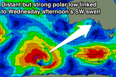
Also in the mix though will be a moderate sized SW groundswell, generated by a strong but weakening polar low developing south-west of WA today, and moving through our swell window over the weekend.
This swell should build to an inconsistent 3-4ft+ across Middleton through the afternoon with 4-6ft sets at Waits but winds will swing from a strong NW'ly through the morning, around to the W/SW into the afternoon as the low pushes east and across us.
Another front pushing in from the west overnight should steer winds back to the W/NW Thursday as the swell eases, creating clean fun waves at Middleton.
Longer term, we're due to see some very inconsistent but strong levels of W/SW groundswell from one of the strongest polar frontal progressions firing up in the Indian Ocean so far this year.
All the activity will be in our far western swell window which isn't ideal, but the progression as a whole is due to push towards and under WA while weakening later next week, helping to overcome this slightly. Also as the Long Wave Trough continues east, follow up W/SW swells are due after the initial long-period pulse.
We should see at least moderate to large amounts of inconsistent W/SW groundswell peaking through next weekend, but we'll have a closer look at this on Monday. Have a great weekend!