Fun waves each morning down South from tomorrow

South Australian Forecast (issued Wednesday 8th April)
Best Days: Every morning down South
Recap
Cleaner but still raw 1-2ft of swell across the Mid Coast yesterday morning before winds swung back onshore, while the South Coast was still a complete mess with a large easing S'ly swell.
Today the Mid was tiny and clean while the South Coast a touch cleaner and smaller but still poor with a fresh onshore wind.
This week and weekend (Apr 9 – 12)
This afternoon a good pulse of S/SW groundswell is due across the South Coast, peaking overnight before starting to ease through tomorrow.
Conditions will improve with an E'ly wind tomorrow morning, that may tend E/NE, but the swell will be quite disorganised and easing from 3-4ft at Middleton and 4-5ft at Waits.
Friday is looking better with a lighter E/NE wind through the morning and fun swell to 3ft at Middleton all day, with 3-5ft sets at Waits and Parsons.
Saturday morning will be the pick of the weekend as winds swing NE and the swell continues to ease from a small 2ft+ at Middleton and 3ft+ at Waits and Parsons. Get in through the morning for the best of it though.
A slight kick in S/SW groundswell is due Sunday from a strong polar front firing up to our south tomorrow, keeping Middleton topped up with 2ft+ waves with 3ft sets at Waits. Conditions are looking good again but not perfect with a morning E/NE wind ahead of S/SE sea breezes.
 Monday onwards (Apr 13 onwards)
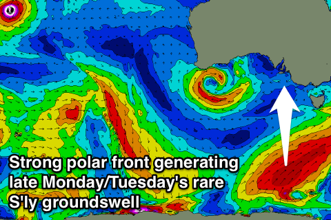
Monday morning will be small and fun early with an easing swell from Sunday under NE winds, but a very acute and rare S'ly groundswell is due into the afternoon/evening.
This will be produced by a strong polar front firing up on the tail of the low generating Sunday's swell. A strong node (peak) of the Long Wave Trough is forecast to move slowly across the southern Tasman Sea over the weekend, directing a vigorous polar front up through our southern swell window.
A fetch of severe-gale S/SW winds will be produced, generating a strong S'ly groundswell for Monday evening, building to 3-4ft across most locations by dark, peaking overnight and easing rapidly from a similar size Tuesday morning.
The Mid should see a new acute W/SW swell filling in Tuesday afternoon from a small cut-off low in the Bight, but we'll look at this in more detail on Friday.