Strong swell for the weekend with average winds

South Australian Forecast (issued Wednesday 14th January)
Best Days: Friday morning for desperate surfers down South, early Saturday morning in protected locations down South, Sunday morning for bigger volumed boards on the Mid, Monday morning down South
Recap
Poor onshore waves down South yesterday with a small weak and building windswell across the Mid Coast through the afternoon.
Today a bigger S/SW swell was seen down South but with persistent onshore winds, while the Mid Coast was a tiny and weak 1-1.5ft.
This week (Jan 15 - 16)
Tomorrow will be another lay day as today's S/SW swell backs off under persistent onshore S/SW winds across the South Coast, while the Mid also looks average with a S'ly breeze and tiny swell.
Friday should be cleaner down South with a morning W/NW offshore but the swell tiny at Middleton and around 1ft+ with Waits offering inconsistent 2ft sets (not worth the drive from Adelaide).
 This weekend onwards (Jan 17 onwards)
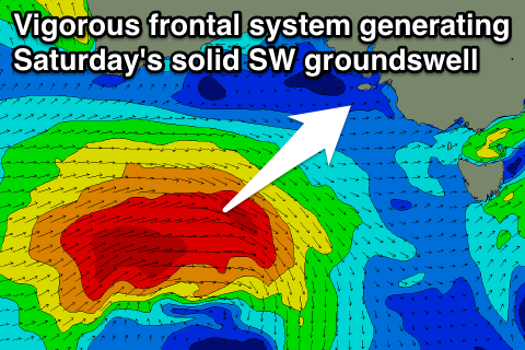
The weekend's swell has been upgraded, with a vigorous and strengthening polar frontal progression, now forecast to come in a lot stronger than predicted on Monday. The evolution of this system will be related to a strengthening node (peak) of the Long Wave Trough across Victoria, with a fetch of gale to severe-gale W/SW winds being projected through our south-western swell window.
This should generate a moderate-large sized SW groundswell for Saturday, peaking through the middle of the day/afternoon to 4-5ft at Middleton with 6ft sets at Waits and 2ft waves on the Mid.
Winds will unfortunately be average and onshore from the SW for the most part, besides a possible small and short-lived window of W'ly winds early around Victor Harbor (when the swell's a touch smaller).
The swell will ease slowly through Sunday and Monday while tending more southerly in direction due to a follow up frontal system continuing to generate a fetch of strong to gale-force SW winds through our southern swell window Saturday and early Sunday.
Winds will remain onshore though into Sunday and from the S/SW to S/SE, while the Mid should be cleaner with a SE'ly but tiny and easing from 1-1.5ft.
Monday looks fun down South as winds swing offshore from the NE (possibly N/NE) due to an approaching front with an easing S/SW swell from 3ft to nearly 4ft across the Middleton stretch and 3-4ft+ at Waits.
Tuesday will be straighter but small and possibly blown out as the front pushes through with strong N'ly winds ahead of a W/SW change.
Longer term we're looking at more healthy swell activity into the middle to end of next week as a secondary series of strong polar fronts project up towards the country, but more on this Friday.