Fun waves to end the week, large swell Tuesday but with onshores down South

South Australian Forecast (issued Wednesday 5th November)
Best Days: Tomorrow both coasts, Friday down South, Sunday both coasts, later Monday and Tuesday on the Mid
Recap
Poor conditions across the South Coast yesterday with a weak building windswell and strong onshore breeze, tiny on the Mid before the swell kicked into the afternoon but with no real quality.
Today the South Coast was still onshore and small while the Mid Coast was tiny but has since increased a touch but with fresh onshore winds.
This week (Nov 6 – 7)
Tomorrow is looking fun across both coasts as a new mix of W/SW and SW groundswell fill in under favourable winds. The W/SW groundswell is a long-range product and will be really inconsistent, while the SW swell was generated by a broad fetch of pre-frontal W/NW winds pushing under the country the last few days.
We should see inconsistent 1-2ft sets across the Mid from these sources, while the South Coast should see 3ft sets along the Middleton stretch with 4ft+ waves at Waits and Parsons.
Winds should be locally offshore across both coasts during the morning as a ridge of high pressure moves in overnight, ahead of weak afternoon sea breezes.
Friday will be best across the South Coast as the swells ease under fresh to strong N/NE winds, that should swing more N/NW through the afternoon and ease. With this in mind, conditions may be a little blustery and blowy at times, but workable across the Middleton to Goolwa stretch and out at Waits and Parsons.
This weekend onwards (Nov 8 onwards)
Saturday is looking poor across both coasts as an onshore change moves through mixed in with a new building W/SW swell across the Mid.
This swell will be generated by a strong frontal system pushing from under WA towards us while weakening and should kick up 1-2ft waves later in the day, holding into Sunday.
Conditions will be poor with a fresh but easing SW'ly, while the South Coast may see an early W'ly around Victor but no real size in the swell.
A better SW groundswell should be seen down South on Sunday generated by a tight and small fetch of SW gales around a low forming at the base of the change pushing through Saturday.
This low will form late in our swell window and not track favourably through our swell window but should still offer 3ft sets at Middleton and 4ft bombs at Waits as winds tend variable (likely from the NE during the morning). The Mid will be clean and fun with the W/SW swell to 1-2ft.
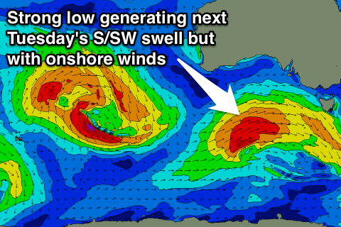 Into next week a much stronger S/SW groundswell is due across the state into Tuesday as a vigorous mid-latitude low pushes in from the west and then projects into Victoria on Monday.
A fetch of W/SW tending SW gales should produce a large S/SW groundswell coming in at 4-5ft+ across Middleton with 6ft+ sets at offshore reefs and Waits/Parsons.
The Mid Coast should see some SW swell initially from the pre-frontal fetch of W/NW winds ahead of the main low and this should build to 1-2ft later Monday and hold into Tuesday.
Winds will be best for the Mid in any case with a fresh to strong S/SW tending S'ly breeze Monday and then SE winds Tuesday when the swell fills in.
A high moving in from the west should swing winds back to the E/NE Wednesday morning but the swell will still be quite lumpy and peaky. We'll review this again Friday though.