Average tomorrow, great from Wednesday

South Australian Forecast (issued Monday 20th October)
Best Days: Wednesday onwards down South
Recap
The weekend started off slow with light onshore winds down South and a small swell, while the Mid was cleaner but tiny.
Sunday offered the best waves with a slight kick in long-range SW groundswell and offshore winds that strengthened into the afternoon with approaching storms.
A late onshore change linked with a deepening trough/front moved through and this has kicked up 2ft+ of windswell across the Mid today, with more swell but similar average conditions down South.
 This week (Oct 28 – 31)
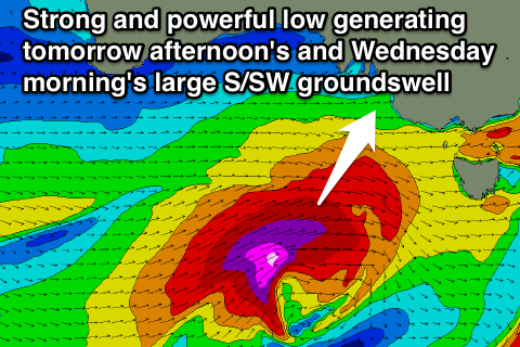
We're now looking at a much larger swell event across the South Coast tomorrow afternoon and Wednesday morning as the secondary front expected in the wake of last nights and this morning's system, has been upgraded significantly.
During today and tomorrow we'll see a fetch of severe-gale to storm-force W/SW-SW winds projected towards Victoria, through our southern swell window, producing a large and powerful long-period S/SW groundswell.
This swell should build through tomorrow from midday, ahead of a peak overnight, but Wednesday morning should still offer the most size.
With the southerly direction there won't be as much as a size disparity between Middleton/Goolwa and Waits/Parsons with most locations due to build to 4-5ft by dark tomorrow with 6ft sets at Waits, while Wednesday morning should reveal 5-6ft sets at Middleton with the possibility for the odd bigger one at deeper water reefs and Waits/Parsons. The Mid Coast will miss out on all of this swell with its southerly direction and come in at 1ft or so, but background SW swell should keep 1-2ft sets hitting tomorrow, easing from 1-1.5ft Wednesday morning.
Winds tomorrow won't be the best with a fresh to strong W/NW'ly expected early around Victor ahead of a shift to the W/SW and then SW through the day.
Wednesday however looks great as winds swing back to the N'th ahead of a weak SW'ly into the afternoon, creating excellent conditions for experienced surfers!
After Wednesday morning's peak in size, the swell will ease off steadily through the afternoon and further into Thursday ahead of a reinforcing S/SW groundswell later Thursday and Friday morning.
This swell won't be as big as Wednesday or as consistent, with it being generated to our south-southwest further towards the polar shelf by a fetch of severe-gale W/SW winds. Still a good pulse of S/SW groundswell is due arriving near dark Thursday, easing Friday from 3-4ft+ at Middleton and 5ft at Waits.
Winds on Thursday will be OK but not perfect with a variable breeze, likely tending locally offshore across the South Coast through the morning, while Friday looks great with offshore N/NE tending NW winds ahead of a late change.
This weekend onwards (Nov 1 onwards)
We've got one more final pulse of solid S/SW groundswell expected across the state over the weekend, arriving late Saturday and peaking Sunday. This will be with poor onshore winds though from the SW Saturday in the wake of Friday's late change and then S/SE Sunday.
Longer term there's nothing major on the cards at all until Thursday week, so make the most of the coming swell.