Fun waves over the coming days, pumping Saturday

South Australian Forecast (issued Wednesday 1st October)
Best Days: Thursday morning both coasts, Friday down South, Saturday down South, Sunday afternoon on the Mid, possibly dawn Monday down South
Recap
Yesterday was OK in protected locations across the South Coast with a building SW swell before winds tended onshore from the W/SW and then SW around lunch time. The Mid Coast was a messy 2ft and built to 2-3ft through the afternoon as onshore winds strengthened.
Today a peak in size was seen across both coasts but conditions poor down South with fresh but easing S/SW winds, while the Mid Coast was cleaner with the S'ly breeze and 2-3ft of swell.
This week and weekend (Oct 2 - 5)
Today's large SW groundswell will ease off through tomorrow across both coasts with fading 2ft sets on the Mid Coast and easing 3-5ft waves at Middleton with 6ft sets at Waits.
Winds will be great for the Mid and light offshore from the E/SE, while the South Coast should be alright with a light variable breeze before SW onshores develop.
The swell will continue to ease into Friday morning, but a strong pulse of S/SW groundswell is due down South through the day, peaking during the middle of the day/afternoon.
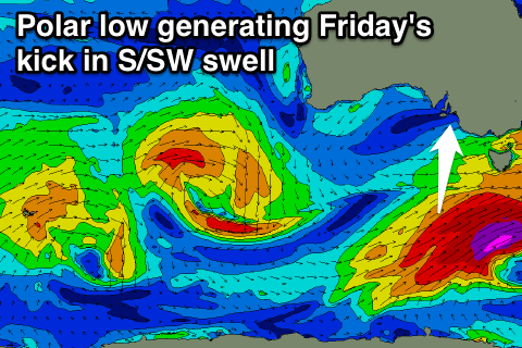 This will be created by a vigorous polar low forming late in our swell window to the south-west of Tassie, aiming a fetch of severe-gale to storm-force S/SW winds on the edge of our swell window today.
This should generate an acute S/SW groundswell coming in at 3-5ft across most locations through the day under fresh NE tending E/SE winds. The Mid Coast will miss out on this swell and ease from the tiny 1ft range.
Saturday is still looking excellent down South as the S/SW groundswell eases from 3-4ft at Middleton, with 5ft bombs at Waits and Parsons under all day offshore N/NW winds.
Unfortunately Sunday will be poor with fresh and gusty S/SE winds after an overnight change, but the Mid Coast should offer clean waves with offshore SE winds, and an afternoon increase in W/SW groundswell to 1-2ft on the incoming tide.
Next Monday onwards (Oct 6 onwards)
Sunday afternoon's increase in W/SW swell is expected to drop away into Monday and besides a short period of favourable N'ly winds early down South, a strong W'ly tending SW change will write-off the surf for the rest of the day.
Longer term we're likely to see some good SW groundswell from a strong weather system passing under the country early in the week, but we'll look at this in more detail Friday.