Excellent Thursday across both coasts

South Australian Forecast (issued Monday 25th July)
Best Days: Tuesday and Wednesday morning down South, Thursday on both coasts, Friday onwards down South
Recap
The South Coast bottomed out in size Saturday under strong offshores ahead of a shift to the W/NW during the afternoon.
Sunday saw a strong new W/SW groundswell filling in, coming in at 2ft on the Mid through the morning and 3-4ft across the South Coast. The swell pulsed strongly through the day with 3ft sets showing on the Mid while the South Coast saw good size across the Middleton stretch but a fresh onshore change spoilt conditions.
This morning the swell was on the way out, easing from an inconsistent 1-2ft on the Mid Coast and the 3-4ft range down South with light local offshores.
This week (Aug 26 - 29)
Today's swell should continue to ease across both coasts with good conditions down South under a light NE'ly. There might be a little bit of peak and wobble around but this should iron itself out into the mid-morning.
Wednesday will be straighter but smaller and only in the 1-2ft range at Middleton with 2-3ft bombs at Waits during the morning under straight N'ly winds.
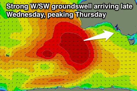 Into the late afternoon though the secondary pulse of strong and inconsistent W/SW groundswell is due across the state, very similar to Sunday's pulse.
This has been generated by another vigorous polar frontal progression in the Southern Indian Ocean, but this system was a touch further south and better aligned in our swell window than the last.
The swell should arrive strongly later Wednesday, pulsing to 2ft on the Mid and 3ft+ at Middleton with 4ft+ sets at Waits ahead of a peak Thursday morning. The Mid Coast should see 2ft to occasionally 3ft sets on Thursday while Middleton should be in the 3-4ft range with 5ft+ sets at Waits.
Winds will be great for both coasts, offshore and from the N'th tending variable down South and NE tending variable on the Mid. The swell will drop steadily Friday as local offshores continued to create good conditions across both coasts. The South Coast will be the standout though.
This weekend onwards (Aug 30th onwards)
The weekend will be fun across exposed spots the South Coast but there's no major size due across the area. Inconsistent levels of background SW groundswell are due under offshore N/NW winds which should persist into the afternoon each day. Sunday should offer the most size with sets to 3ft at Waits and Parsons.
Longer term a new medium sized S/SW groundswell is due across the state through the middle of next week, but we'll look at this again Wednesday.