Easing swell, with new energy from early-mid next week

Bali and Mentawais forecast by Craig Brokensha (issued Thursday 25th October)
Best Days: Swell magnets tomorrow and Saturday morning, similar Tuesday morning and then Wednesday onwards
This week through next week (Oct 26 – Nov 2)
Bali: Our good large S/SW groundswell seen yesterday afternoon is still solid this morning but is now on the ease and we'll see it continuing to drop across the region tomorrow morning from 5-6ft at south swell magnets, smaller on the Bukit.
The surf should continue to ease through Saturday and Sunday, bottoming out Monday across the region. We should see the trades kick back in from the SE tomorrow, variable through the morning, persisting into next week, though a bit of a southerly bias is still expected Sunday through Tuesday.
 Our next increase in size is due Tuesday afternoon and more so through Wednesday and Thursday, that being an inconsistent but fun sized S/SW groundswell followed by a slightly better SW pulse Wednesday afternoon and Thursday morning.
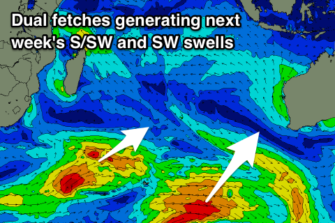
The S/SW energy is currently being generated by a slow moving polar fetch of strong to gale-force W/SW winds east of Heard Island, and this should arrive Tuesday, building slowly towards 4-5ft at exposed breaks by late in the day, holding a similar size Wednesday morning.
The secondary more SW angled swell will be generated by a slightly stronger but thinner fetch of W/SW gales projecting up from the south-east of Madagascar, north of the Heard Island region before then weakening and tracking back east-southeast.
Better 6ft sets at magnets are due into Wednesday afternoon and Thursday morning when the swell fills in, with a slow drop in size Friday, more noticeable through next weekend.
Longer term there's nothing too major on the cards besides a small to moderate sized mid-period S/SW swell, but we'll have another look at this on Tuesday.
16 day Bali Forecast Graph
16 day East Java Forecast Graph
16 day Sumbawa Forecast Graph
Ments: We should be seeing good sized surf breaking across the region today, with an easing trend expected from this afternoon, further through tomorrow and the weekend.
The surf will bottom out Sunday and Monday with small inconsistent levels of background swell in the 3ft range at magnets, with the new S/SW groundswell building Tuesday though coming in smaller across our region due to it being generated later in our swell window.
Exposed south facing breaks should reach 4ft, with a further increase in size on Wednesday to 4-6ft with the SW energy, easing slowly from 4-5ft Thursday, smaller into the end of the week.
Winds over the coming period look good and out of the E/SE-SE each morning, S'ly into the afternoons, following this pattern most of next week besides Monday when a small surface low may develop. This will bring variable tending W/NW winds.
16 day Mentawai forecast graph
16 day Nias forecast graph
16 day South Sumatra forecast graph