Fun swell to end the week, good swells mid-late next week

Bali and Mentawais forecast by Craig Brokensha (issued Tuesday 9th October)
Best Days: Thursday through Monday and then Wednesday onwards next week
This week through next weekend (Oct 10 - 19)
Bali: Smaller surf after some good S/SW groundswell on the weekend, and the waves will remain on the smaller side through tomorrow ahead of our long-range and inconsistent SW groundswell Thursday/Friday.
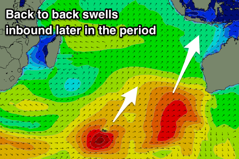
This swell was generated last week by a broad and slow moving fetch of gale to severe-gale W/SW winds that developed under South Africa and projected east before breaking down around the Heard Island region.
 The swell will be from a good direction but really inconsistent with not much in between sets, with a building trend through Thursday afternoon, reaching 3-5ft by dark and then peaking Friday to 6ft on the sets.
The swell is then due to ease through Saturday, smaller Sunday and further Monday and Tuesday morning.
Weak E/SE-SE trades are due over the coming period, variable each morning with local land breezes.
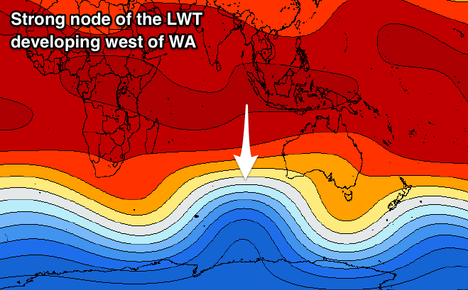
From the middle of next week we'll see a good run of groundswell, generated by a flurry of strong polar and mid-latitude frontal activity under the influence of a strong node of the Long Wave Trough developing west of Western Australia.
The exact structure of the frontal progression is still up in the air but we're likely to see swell pulses in the 6-8ft range from mid-next week through the weekend. More on this Thursday.
We may see winds go funky at this time as a tropical depression drifts in from the west, swinging winds more S'th, but check back Thursday.
16 day Bali Forecast Graph
16 day East Java Forecast Graph
16 day Sumbawa Forecast Graph
Ments: For the Ments firstly we've got better winds expected from tomorrow with morning E/SE trades, S'ly into the afternoon and then tending more N-NW on Thursday as a small tropical low lingers around the region.
 NW winds are then due Friday and Saturday morning before the low weakens and we see afternoon NE breezes, more variable into Sunday and then back to the S/SE early next week.
Swell wise tomorrow will remain small, but the new SW groundswell should build Thursday and reach 6ft on the sets by dark, holding a similar size into Friday morning, if not for the odd sneaker at magnets.
The swell should then ease into the weekend, further next week ahead of the groundswell energy due mid-late next week.
These swells will come from a more southern angle across our region and look to be more in the 6ft+ range, if not for one bigger day, but more on this Thursday.
16 day Mentawai forecast graph
16 day Nias forecast graph
16 day South Sumatra forecast graph