Not the best outlook for the region

Bali and Mentawais forecast by Craig Brokensha (issued Tuesday 28th August)
Best Days: Swell magnets over the coming period
This week and next (Aug 29 – Sep 7)
Bali: Following large easing surf over the weekend, a good reinforcing pulse of new groundswell was seen yesterday, easing off through today.
We'll see the surf continuing to ease through tomorrow bottoming out on Thursday. We're looking at weaker winds out of the S/SE over the coming days, variable each morning before reverting back to the SE and then E/SE later week.
 As we move into the end of the week, our new inconsistent S/SW groundswell is still on track, but there'll also be a more consistent and larger mid-period S/SW swell in the mix as well.
The groundswell was generated by an intense polar low forming east of Heard Island, late in our swell window. A fetch of severe-gale to storm-force W'ly winds were produced, generating a good long-period S/SW groundswell that should arrive through Friday and build to 6ft+ across south swell magnets, easing Saturday.
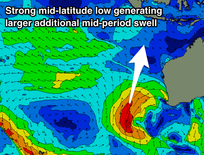
Building at the same time though will be a large mid-period S/SW swell, generated by an intense mid-latitude low off WA today and tomorrow.
A great fetch of strong to gale-force S/SW winds are being projected up through our swell window, with the low stalling tomorrow and continuing to generate a good S'ly fetch in our southern swell window.
We'll see a large consistent mid-period S/SW tending S'ly swell, arriving Friday and building to 8ft on the sets across south swell magnets through the afternoon, easing from a similar size on Saturday morning.
The swell will slowly ease out of the south on Sunday, smaller into early next week.
A very inconsistent long-range S/SW groundswell is due Monday afternoon, but to no additional size above the existing easing S'ly swell.
It looks like the surf will bottom out into the middle of next week, Wednesday/Thursday, with the next increase in swell due Friday.
This looks to be a good large sized S/SW groundswell event, but more on this Thursday.
16 day Bali Forecast Graph
16 day East Java Forecast Graph
16 day Sumbawa Forecast Graph
Ments: The swell is easing across the Ments as well with winds out of the S/SE, with a further drop in swell expected through tomorrow and Thursday, bottoming out into the evening.
Winds should be favourable each morning and out of the E/SE before reverting back to the S/SE into the afternoons.
The S'ly swells due across Bali weren't generated favourably in our swell window at all, with the best pulse due on Saturday out of the S/SE from the mid-latitude low off WA.
A late increase in size is expected Friday with a peak Saturday to 6ft on the sets across exposed south magnets, easing back slowly through Sunday and Monday.
Winds will improve and be light out of the E/SE each morning and more variable into the afternoons from the weekend, redeveloping out of the S/SE through early next week.
We'll see smaller background energy across the region into the middle of next week ahead of the possible larger S/SW groundswell later week. More on this Thursday though.
16 day Mentawai forecast graph
16 day Nias forecast graph
16 day South Sumatra forecast graph