Great SW swell next week

Bali and Mentawais forecast by Craig Brokensha (issued Thursday 9th August)
Best Days: Friday Ments, Saturday through Monday, Wednesday onwards
This week and next (Aug 10 - 17)
Bali: The swell is bottoming out across the Indonesian archipelago with easing mid-period S/SW swell, smaller into tomorrow morning.
Some new inconsistent background SW groundswell energy should slowly build through tomorrow, with no real size likely until late ahead of a slightly better increase due through Saturday.
The small tight low linked to Saturday's swell is now pushing across WA, with strong S/SW winds in our southern swell window, producing a reinforcing mid-period S/SW swell for Sunday.
Looking at the expected size and later Friday magnets should build to 3-4ft+ as gusty SE trades kick in, with Saturday building slightly further to 4-6ft. Sunday's swell has been upgraded a little with sets likely to kick to a more consistent 6ft across magnets, if not for the odd bigger one into the afternoon.
We'll see the swell drop steadily through Monday from 4-5ft+, small Tuesday and bottoming out late in the day.
Fresh SE trades will continue on Saturday, tending more E/SE from Sunday and persisting all of next week. Early each morning though we'll see lighter more variable breezes due to local land breezes.
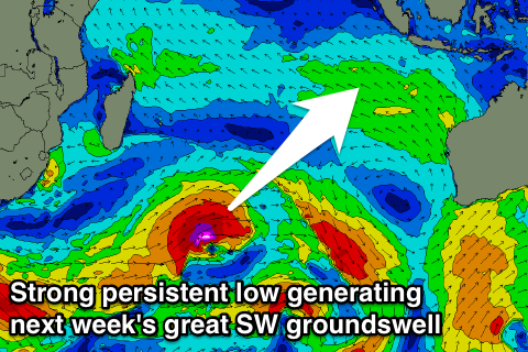 The new SW groundswell due mid-late week is still on track, with a strong but distant low firing up south-east of South Africa. This low will generate a fetch of severe-gale W/SW winds quite north in latitude, with core wind speeds likely to reach the storm-force range.
As the low starts to weaken, a secondary smaller embedded system will piggy-back on top of it, helping prolong the peak of the swell through later next week.
We should see a good long-period SW groundswell arriving through Wednesday and building to an easy 6ft into the afternoon, likely larger on dark, with a peak Thursday to a strong 6-8ft, easing back a touch into Friday morning.
A third pulse of S/SW groundswell is due through Friday generated by a tail fetch of SW gales firing up west of WA on the backside of all the storm activity.
This should keep the surf up around 6ft+ all day, easing through Saturday.
Longer term there's a few different swell possibilities, but more on this Tuesday.
16 day Bali Forecast Graph
16 day East Java Forecast Graph
16 day Sumbawa Forecast Graph
Ments: Some new background SW groundswell should be on the build later today, with it due to peak tomorrow to 4-6ft across swell magnets, holding Saturday morning before dropping back slowly through the afternoon and more noticeably Sunday.
We'll see winds persist out of the SE-E/SE tomorrow and Saturday with more variable winds Sunday favouring magnets as the swell fades.
It looks like the swell will bottom out into Monday and Tuesday morning ahead of the large new long-period SW groundswell.
This looks to arrive later in the day Tuesday with Wednesday seeing solid and powerful 6-8ft sets across magnets, easing slowly Thursday from the 6ft+ range.
Winds look as of they'll kick back in from early next week out of the S/SE-SE, strong and gusty through the peak of the swell next Wednesday.
16 day Mentawai forecast graph
16 day Nias forecast graph
16 day South Sumatra forecast graph