Good swell pulses from Thursday through next week

Bali and Mentawais forecast by Craig Brokensha (issued Tuesday 10th April)
Best Days: Thursday onwards across all regions
This week and next (Mar 11 - 20)
Bali: Friday's swell came in on forecast with very inconsistent but strong sets to 6ft across magnets (photo thanks to Joey), easing gradually through the weekend and further into this week.

We'll see small surf continue over the coming days ahead of a large new S/SW groundswell Thursday/Friday.
This swell built across West Oz yesterday and has peaked this morning, and we'll see the same swell building Thursday, and likely peaking overnight, dropping back through Friday.
Sets in the 6ft+ range are likely later Thursday and early Friday, easing back into Saturday. Weak E/SE trades will create good conditions, light and variable each morning and locally offshore.
Moving into Sunday/Monday we're looking at our secondary larger groundswell event, with a mix of SW and S/SW energy due to fill in around the same time.
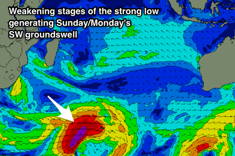 A very intense mid-latitude low formed south-east of South Africa on Sunday, generating a fetch of severe-gale to storm-force W/SW winds in our south-western swell window before dropping south-east towards Heard Island while maintaining similar strength winds.
This has generated a large long-period and inconsistent SW groundswell, but a secondary intensification of SW gales projected up towards WA over the coming days will generate a slightly smaller but more consistent S/SW groundswell.
We're due to see both swells arriving around the same time, that being through Sunday morning when forerunners to 20s+ fill in, but without any size, ahead of the bulk of the groundswell through the afternoon, peaking Monday morning.
We should see exposed breaks building to 6-8ft later Sunday, with a peak Monday morning in the 8ft range, if not for the odd bigger cleanup set at known magnets, easing through the day, smaller from 6ft+ Tuesday morning.
Moderate to fresh E/SE trades are due to create clean conditions through early next week, lighter and more variable early each morning.
Longer term a slow moving and initially unfavourably aligned mid-latitude is expected to form in the central southern Indian Ocean, producing a small to moderate sized SW groundswell for Friday. Beyond this a much broader and more significant polar frontal progression looks to generate a large swell for the weekend of the 22/23rd, but more on this Thursday.
16 day Bali Forecast Graph
16 day East Java Forecast Graph
16 day Sumbawa Forecast Graph
Ments: Our current run of very small surf will end on Thursday, with the new S'ly groundswell from the frontal activity pushing up towards WA due to fill in.
There's been no real change to the expected size, with building sets to the 5ft range across south swell magnets due by late in the day, holding a similar size Friday and then easing slowly into Saturday.
The mix of SW and S/SW groundswell should follow a similar trend to Bali, building Sunday and reaching an inconsistent 6ft on the sets by dark, with a peak Monday morning around 6ft to possibly 8ft at magnets.
Winds through this period look variable creating favourable conditions each day.
On the back of Monday morning's swells, later in the week the swell from the mid-latitude low is due to fill in. This is better aimed for us than Bali and looks to offer surf to 4-6ft Thursday afternoon, easing Friday ahead of the larger swell on the weekend.
16 day Mentawai forecast graph
16 day Nias forecast graph
16 day South Sumatra forecast graph