Easing SW groundswell, new S/SW swell for Monday

Bali and Mentawais forecast by Craig Brokensha (issued Thursday 31st August)
Best Days: Protected spots tomorrow and Saturday morning, Monday through Tuesday then more exposed breaks from Wednesday
This week and next (Sep 1 - 8)
Bali: We've seen the very inconsistent but strong and great SW groundswell filling in today with fun waves across the reefs.
This swell is due to peak tomorrow in the 6ft range across magnets, easing off slowly into Saturday and further Sunday.
We then look towards the large S/SW groundswell due early next week.
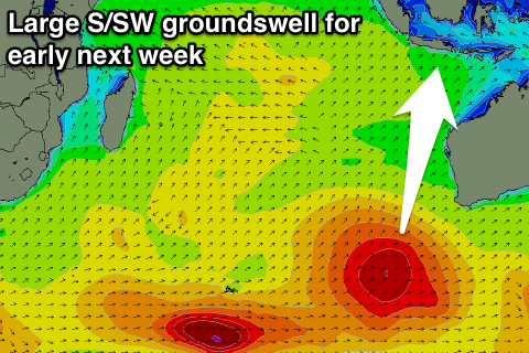 The initial broad and strong polar front has projected towards WA, and we're seeing the secondary intensification of it now projecting an additional fetch of weakening S/SW gales up through our southern swell window.
The whole progression has formed as one solid swell generator, with a large consistent S/SW groundswell due to result, building on dark Sunday and peaking Monday to 8ft across exposed breaks, easing back slowly Tuesday from 6-8ft.
Moderate to fresh E/SE trades are due over the coming period, lighter and more variable each morning with local land breezes.
Our reinforcing long-period S/SW groundswell is still on track for Wednesday, but while the storm generating this swell will be stronger, it wills stick to the polar shelf, resulting in less size and consistency.
This swell should build later Wednesday, reaching an inconsistent 6ft on the sets, easing back from a similar size Thursday.
Beyond this there's nothing major on the cards, so make the most of the coming swells.
16 day Bali Forecast Graph
16 day East Java Forecast Graph
16 day Sumbawa Forecast Graph
Ments: We're see the new SW groundswell offering great waves in protected spots today with the S/SE breezes.
This swell should be hitting the 6ft+ range, withy a slow drop due through tomorrow, further into the weekend. Unfortunately fresh SE winds will persist until the middle of next week, when the'll finally become more variable.
Monday's large S'ly groundswell from the strong polar frontal progression firing up towards WA should come in around 6ft+ across south facing breaks on Monday, easing back into Tuesday and further Wednesday.
The reinforcing but less consistent S'ly groundswell due mid-week is expected to peak Thursday morningacross our region but only to 3-5ft before easing back through the rest of the week.
Longer term a fun but inconsistent long-range SW groundswell is due Sunday/Monday, but more on this next update.
16 day Mentawai forecast graph
16 day Nias forecast graph
16 day South Sumatra forecast graph