Good swells pulses early next week and weekend

Nias, Mentawai, South Sumatra forecast by Craig Brokensha (issued Thursday 29th October)
Best Days: Portected spots from tomorrow afternoon, more exposed breaks from Wednesday
This week and next week (Oct 30 – Nov 6)
The surf is bottoming out across the islands today, but some fun new SW groundswell is due to build through tomorrow and peak Saturday. We should see inconsistent but strong 4-5ft+ sets develop later tomorrow, peaking Saturday in the 5-6ft range.
A drop is then due into Sunday ahead of a stronger S/SW groundswell pulse Monday afternoon and Tuesday.
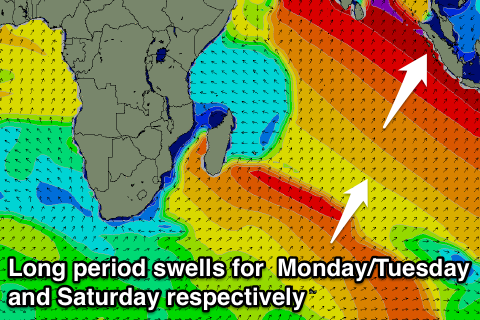 This swell has already been generated by a vigorous and broad polar frontal progression that developed west of Heard Island a couple of days ago. The swell from the progression should build strongly Monday afternoon and reach 6ft+ later in the day on the sets, easing from a similar size early Tuesday.
Fresh S/SE winds will kick in again from tomorrow though and persist through the weekend and early next week before weakening from next Wednesday.
The swell should drop away slowly through Wednesday and Thursday, bottoming out Friday morning, ahead of a new S/SW groundswell pulse through the afternoon, peaking Saturday.
This groundswell will be generated by a slightly stronger system compared to the low that produced Monday's swell, but later in our swell window resulting in a touch less size and more S'ly direction.
The swell should kick later Friday to the 4-6ft range, peaking Sunday to 5-6ft or so. Lighter S/SE winds are expected but we'll look at this again next update.