Easing S/SE winds with moderate swell pulses

Nias, Mentawai, South Sumatra forecast by Craig Brokensha (issued Thursday 22nd October)
Best Days: Every day from Saturday
This week and next week (Oct 23 - 30)
Yesterday's good pulse of S/SW groundswell has dropped back quickly into today and will continue to ease into tomorrow, bottoming out into the evening.
Into Saturday a new moderate sized S/SW groundswell is due, generated on the edge of our swell window by an expansive but not overly strong polar frontal progression south-west of WA.
Exposed break should peak through the day to an inconsistent 4-5ft or so, easing back slowly through Sunday.
Moderate to fresh S/SE trades tomorrow are due to ease into Saturday and further Sunday with weaker S/SE winds Monday and Tuesday, becoming variable from Wednesday.
 Into next week a good pulse of inconsistent S/SW groundswell from under South Africa is due, building through the afternoon to an inconsistent 4-6ft across exposed breaks, easing back from 4-5ft Tuesday morning, further down into Wednesday and Thursday.
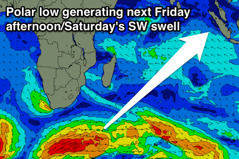
Longer term a good but inconsistent SW groundswell is due Friday afternoon, peaking Saturday, produced by a healthy frontal system firing up under South Africa this evening and through tomorrow.
Exposed breaks should build to 4-5ft+ later Friday and then peak on Saturday to 5-6ft before tailing off into Sunday.
16 day Mentawai forecast graph
16 day Nias forecast graph
16 day South Sumatra forecast graph