Average outlook continues

Nias, Mentawai, South Sumatra forecast by Craig Brokensha (issued Tuesday 21st Jul)
Best Days: Exposed spots from Thursday afternoon
This week and next week (Jul 22 – 31)
 Our run of small to moderate S/SW swell is expected to continue through this week, with the most size due into Thursday afternoon/evening and Friday, from a relatively weak but broad frontal system pushing up and into WA, on the edge of our swell window.
This should produce an inconsistent pulse of mid-period swell, building to 4-5ft Thursday afternoon and peaking Friday in the 4-6ft range at exposed coasts. A drop is then due into Saturday and further Sunday.
Winds will freshen from the S/SE tomorrow but then ease into Thursday and back to the light to moderate range Friday and through the weekend.
Into later Sunday, more so Monday a new pulse of S'ly groundswell is due, generated by a slightly stronger but smaller in scope, polar front pushing north-northeast up towards WA today and tomorrow.
This should see inconsistent 4-5ft sets across exposed south facing breaks Monday morning, before easing into the afternoon and further Tuesday.
South Sumatra will be a touch bigger through each swell peak, while Nias will be opposite and a touch smaller than the Ments.
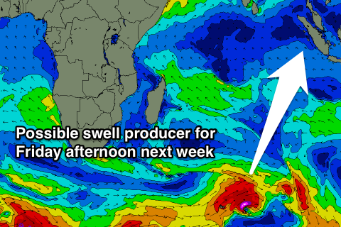
For the rest of the week there's nothing too significant on the cards besides a moderate pulse of S/SW groundswell Friday afternoon, possibly to the 6ft range. More on this Thursday though.
16 day Mentawai forecast graph
16 day Nias forecast graph
16 day South Sumatra forecast graph