Good period ahead, large swell due next week

Nias, Mentawai, South Sumatra forecast by Craig Brokensha (issued Tuesday 26th Mayl)
Best Days: Every day over the coming period
 This week and next week (May 27 – Jun 5)
The recent inconsistent SW groundswell is now on the ease, but we should see some better sized S/SW groundswell into tomorrow before tailing off into the start of the weekend.
This S/SW groundswell was generated late last week and should peak through the afternoon to 5-6ft across exposed breaks before easing from 4-5ft Thursday morning.
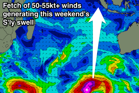
The S'ly trade-swell talked about last week has been downgraded a touch in size, with the stationary fetch of strong SE winds generating this swell now forecast to be positioned further east and more out of our swell window.
There should still be small amounts of S'ly swell from Friday through Monday, peaking over the weekend to an inconsistent 3ft+ or so across south swell magnets.
Luckily, the S/SW groundswell also due at the same time over the weekend, has been upgraded in size a touch, with the vigorous polar low generating the swell forming more within our swell window.
This low has already generated a fetch of storm-force W'ly winds perpendicular to our swell window, which isn't great, but it's since moving north-east, projecting severe-gales on the edge of our southern swell window.
We should see this swell impact Southern Sumatra with more size than the Ments, and even smaller in Nias.
The swell should build through Saturday, pulsing strongly into the afternoon and late in the day, reaching a very inconsistent 6ft+ across exposed breaks by dark around the Ments, before easing from a similar size Sunday morning, further into Monday and Tuesday.
Winds are due to be generally light and variable from the S/SE over the period, before increasing a touch into the middle of next week.
Longer term, a new long-range and large SW groundswell is due Wednesday and Thursday next week, generated by a vigorous polar frontal system firing up to the south-east of South Africa and Madagascar.
This is expected to come in at an infrequent 6-8ft across the Ments Thursday morning, but we'll have another look at this on Tuesday.
16 day Mentawai forecast graph
16 day Nias forecast graph
16 day South Sumatra forecast graph