Smaller swells with generally light winds

Nias, Mentawai, South Sumatra forecast by Craig Brokensha (issued Tue 19th Mayl)
Best Days: Every day over the coming period
 This week and next week (May 20 – 29)
An easing S/SW groundswell should be seen across the region through today, with this swell due to ease further into tomorrow before steadying Thursday to an infrequent 3-4ft+ across exposed south facing breaks with generally light and variable winds.
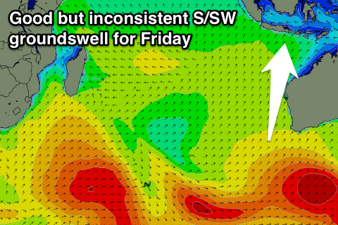
A new S'ly groundswell is due Friday, generated on the edge of our southern swell window to the south-southwest of WA over the weekend.
This swell will be extremely inconsistent with exposed south facing breaks due to offer 4-5ft+ waves Friday before easing away through Saturday and bottoming out Sunday morning.
A better but similarly inconsistent SW groundswell is then due to build through Sunday and peak Monday, generated to the south of South Africa Saturday and Sunday by a vigorous polar frontal system.
This swell should build to 3-5ft late in the day across the Ments before peaking Monday to 4-5ft+ as winds start to increase a touch from the S/SE.
A drop in size is due Tuesday ahead of a new S/SW groundswell Wednesday. This looks to be back to 4-5ft, before easing into the end of the week as winds become more variable.
Longer term there's a possible new S/SW groundswell due the weekend of the 30/31st but the models are still a little divergent on this. We'll have a closer look at this on Thursday though.
16 day Mentawai forecast graph
16 day Nias forecast graph
16 day South Sumatra forecast graph