Indonesia/Maldives forecast Jul 29

Indian Ocean Basin analysis by Craig Brokensha (issued Tuesday 29th July)
This week through next (July 30 - Aug 8)
Following the weekend’s swell, the surf has been on the ease, but a new, inconsistent S/SW groundswell should be in the water today, with an upgrade in the S/SW swell due tomorrow.
Tomorrow’s energy was expected to be mostly mid-period energy, with more size than today but the frontal progression up and into Western Australia was a little stronger than forecast late last week, with an upgrade in the strength and expected size due.
The swell is due to fill in tomorrow with strong 8ft+ sets due across the exposed breaks (peaking into the afternoon), easing gradually through Thursday, smaller Friday.
A small, background S/SW groundswell is likely Saturday, though the source was a strong, south-east tracking low forming late in our swell window. With this don’t expect much size or consistency.
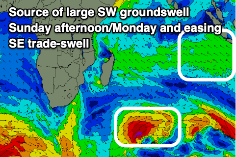
Of greater significance is the increase in groundswell energy due through next week, though in short we’ve got a downgrade in size thanks to the strong progression linked to a possible large SW groundswell breaking down into smaller, unconsolidated systems which will result in smaller, separate pulses of groundswell.
Firstly, a strong mid-latitude frontal system pushing high above the Heard Island region today and tomorrow should generate a large SW groundswell for Monday (building Sunday afternoon), a similar size, reinforcing S/SW for later in the day/Tuesday morning generated by a secondary intensification of the storm north-east of the Heard Island region Thursday.
We should then see a stronger, more sustained fetch of severe-gale SW winds projected north-east towards Western Australia through Friday/Saturday, generating the largest pulse of S/SW groundswell for Wednesday.
The models are still slightly divergent on the makeup of this progression so check back here Thursday for a clearer idea on the timing and sizes.
Our local, strong SE trades are expected to ease over the coming days, swinging more E/SE into the weekend and freshening a little through next week. Light, local offshore winds are due each morning.

In the Mentawais, the first swell for Sunday afternoon/Monday looks large with the secondary pulses coming in more S’th but still large and significant.
We’ve also got a sizey S/SE trade-swell in the water thanks to strong SE winds setup south-west of us that will slowly break down over the coming days.
Local, strong S/SE-SE winds across the southern regions are expected to start easing tomorrow, becoming variable into Thursday, possibly freshening from the N/NW-NW across northern and central locations from Sunday.
----------------------------------------------
Maldives:
The S/SE trade-swell is kicking in size across the region today, with the largest and strongest pulse from a great fetch of SE trades to the south-west of Sumatra expected to fill in tomorrow afternoon.
The swell will then slowly back off from Thursday, further into the weekend though not below the moderate sized range as a result of the trade-fetch weakening but still holding through until Thursday.
We’ve then got another significant surge of S/SE trades south of us from Friday through the weekend, kicking up another fresh pulse of large S/SE trade-swell early next week.
S’ly groundswell wise, the strong frontal system pushing north of the Heard Island region over the coming days should produce a moderate + sized S/SW groundswell for Sunday afternoon, easing Monday.
Local winds are strengthening from the W/NW-NW and will tip more NW over the coming days, only easing from the weekend and then possibly picking up again from the W/NW next week.
Eastern Indonesia:
Large S/SW groundswell filling in tomorrow, reaching 8ft+ across exposed breaks, easing slowly into the end of the week.
Small to moderate sized, inconsistent S/SW groundswell Saturday.
Large SW groundswell for later Sunday, peaking Monday morning to 6-8ft with a secondary slightly bigger S/SW groundswell for the afternoon to 8ft.
Larger S/SW groundswell likely Wednesday.
Strong SE trades easing over the coming days, swinging more E/SE into the weekend and freshening a little through next week. Light, local offshore winds are due each morning.
Uluwatu 16-day Forecast Graph/WAMs
Western Indonesia/Mentawais/South Sumatra:
Large S’ly groundswell building tomorrow afternoon to 8ft across exposed breaks, easing slowly into the end of the week.
Moderate + sized S/SE trade-swell also in the mix.
Large SW groundswell building Sunday afternoon to 6-8ft, holding Monday morning.
Secondary pulse of S’ly groundswell likely Tuesday morning to 6-8ft.
Possible third larger S’ly groundswell Wednesday.
Local, strong S/SE-SE winds today easing tomorrow, becoming variable into Thursday, possibly freshening from the N/NW-NW across northern and central locations from Sunday
Mentawai 16-day Forecast Graph/WAMs
Maldives:
Large pulse of SE trade-swell tomorrow, peaking into the afternoon to 6ft+ across exposed breaks (smaller Male), easing slowly into the end of the week and weekend.
Moderate + sized S/SW groundswell building Sunday, peaking to 4-5ft into the afternoon, easing Monday.
Large S/SE trade-swell building into early next week to 6ft+ across the southern atolls, smaller Male.
Strengthening W/NW-NW winds, tending more NW over the coming days, only easing from the weekend and then possibly picking up again from the W/NW next week.
Comments
Latest notes are live
I was trying to find that couple of paragraphs that you had written previously about + and - IOD and how it affects the surf in the Maldives but to no avail. Could you direct me to it or rewrite it when you have time. Thanks Craig
Yeah, effectively - IOD means less swell from the SE and stronger west winds across the region, with + IOD bringing more SE swell and lighter if not east winds across the region.
Right now we're neutral-ish if not tending slightly - IOD.
So the colder water approaching the Maldives under a neg IOD is from upwelling off the African continent?
Also curious why/what causes the stronger currents in the Maldives under a neg IOD?
Do you have "typical" Indian Ocean synoptic charts under a + and - IOD please Craig?
It'd be from stronger west winds feeding into the lower pressure forming over the warm water off Indonesia. When I get a chance I'll have a scope.
Thank you Craig
Thanks Craig, got all excited at 4.30 am when doing stretches as could feel the SW offshore, unfortunately it swung to S by 5.30 am . Aw & I paddled out at sparrows fart anyway and got 6 lumpy bumps well overhead before calling it as wind increased from SE . Tried again at 10.30 am as looked to be backing off , bigger again but still very bumpy making drops and bottom turn interesting. Had 4 waves and a very black storm was heading our way and blew it out completely . The forecast looks good for swell but we look likely to be skunked by winds unfortunately , particularly later when the NNW winds hit with some strength and consistency. Can’t win them all , first week was reasonably good with conditions and swell. Geez it’s been a year of NNW up here .
Have you @ AW been surfing the other side of the Island Supa?
Fitzroy-21. Hi mate
We haven’t surfed the other side yet. On a windy day at LR we went to LLeft, three big boats and a small one, waves weren’t that impressive.
Looked at Bintangs a couple of times but pretty small, only a few on it.
Over the next few days we may end up over there with a bigger swell and slightly more favourable offshores because the wind for LR doesn’t look very good at all. AW
Nice AW, enjoying all the commentary on the various threads.
Was just curious due to the wind on LR. I have had some memorable surfs on LL especially with LR being crowded.
Enjoy
@fitz , a few days have definitely been much cleaner on the other side but I’ve been opting to surf light onshore out front with sometimes only a couple of others , while up to 5 boats have been at LL. A bloke that lives here surfed the left at bintangs last week when swell was up , said it was 4-6 ft and breaking like chopes , only a few on it , one young guy broke 2 boards in succession and another creased. I’ve never surfed the right at bintangs so maybe soon as its best in a northerly . Have you surfed there ?
I've surfed Bintangs, super fun, kinda short bowly right. Offers a nice barrel as well. Kinda of like a right, rip-bowl reef setup.
Nice one Supa. LL can be really good, especially when uncrowded.
Only surfed Bintangs once and it was a bit small. As Craig mentions, hollow short right, fun though.
Enjoy.
Not sure how JC and his magical mystery tour are going to go at his secret location that works in SE winds .