Indonesia/Maldives forecast Jun 10

Indian Ocean Basin analysis by Craig Brokensha (issued Tuesday 10th June)
This week through next (Jun 11 - 20)
Our inconsistent long-range SW groundswell from the weekend and yesterday is now slowly easing, but a reinforcing pulse should be in the water today, slowing this trend as trades really strengthen.
Looking at the coming week and an initial, moderate sized SW groundswell for tomorrow is still on track, with an upgrade in the SW groundswell due later week.
A healthy fetch of W/SW gales that formed south-east of Madagascar last week will generate tomorrow’s SW groundswell with it due to peak through the day and come in a little bigger across the Mentawais.
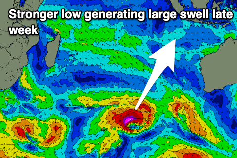
We then look at the strong mid-latitude low that formed north-east of the Heard Island region on the weekend, with a great fetch of severe-gale to storm-force W/SW-SW winds generated through Indonesia’s southern swell window as the system moved slowly east.
This should produce a large SW groundswell above model estimates, with it due to arrive strongly Thursday afternoon, kicking large late but likely peak Friday morning.
A slow easing trend is then due through the afternoon, further Saturday ahead of a low point Sunday morning.
Later in the day Sunday but more so Monday, a new, inconsistent SW groundswell is due to arrive, generated by an expansive but not overly strong frontal progression that formed south-east of South Africa yesterday, and is now pushing east across the Heard Island region.

There’ll be a couple of pulses of swell from later Sunday through Tuesday though Monday looks to be the peak with moderate + sized surf.
Longer term a much more significant frontal progression pushing high into the Indian Ocean later this week and through the weekend should generate a large run of consistent SW groundswell from Friday next week but we’ll have a closer look at this on Thursday.
The current strong E/SE trades are expected to ease slightly into the weekend before picking back up into the evening Sunday, possibly backing off again mid-late in the week.
Over in the Mentawais, the coming SW swell looks best with the S/SW energy for later week coming in a touch smaller though still large and above model forecasts.
The current W/NW-NW wind surge will back off into this afternoon and evening, with variable breezes due, possibly freshening from the SE across southern locations into the weekend, variable again next week.
----------------------------------------------
Maldives:
Our current mix of S’ly groundswell and S/SE trade-swell will ease into this afternoon, but we’ve got a fresh, larger increase in mid-period S-S/SE swell tomorrow, holding Thursday morning before easing slowly into Friday/Saturday.
The source is a great fetch of strong SE trades that have set up south of us, with the fetch due to start breaking down this evening and further tomorrow, persisting through the end of the week but in a weaker form.
Otherwise the activity south-east of South Africa firing up yesterday should produce a moderate sized, inconsistent S/SW groundswell for later Saturday but more so Sunday, easing Monday.
Longer term the larger groundswell energy on the cards for late next week in Indonesia is due next Thursday, but more on this next update.
Our current strong W’ly winds (weaker SW across southern locations) will persist all week, even strengthening into the weekend, slowly easing through next week.
Eastern Indonesia:
Moderate + sized, SW groundswell tomorrow, reaching 5-6ft across exposed breaks.
Larger S/SW groundswell for later Thursday, peaking Friday morning to 8ft
across exposed breaks, easing into the afternoon and Saturday.
Inconsistent moderate + sized SW groundswell building later Sunday, peaking Monday to 5-6ft across exposed breaks.
Larger SW groundswell likely late week.
Strong E/SE trades, easing a touch over the weekend before possibly increasing again early next week. Variable, local offshore winds each morning.
Uluwatu 16-day Forecast Graph/WAMs
Western Indonesia/Mentawais/South Sumatra:
Large SW groundswell tomorrow to 6ft+ across exposed breaks.
Moderate to large S’ly groundswell for later Thursday but more so Friday to 6ft to possibly 8ft across exposed breaks.
Moderate + sized S/SW groundswell for later Sunday and Monday to 5-6ft across exposed breaks.
Large SW groundswell to 8ft likely next Thursday/Friday.
Variable winds this period possibly freshening from the SE across southern locations into the weekend.
Mentawai 16-day Forecast Graph/WAMs
Maldives:
Moderate to large sized mid-period S tending S/SE swell for tomorrow afternoon and Thursday morning to 6ft+ across southern locations, 4-5ft central locations.
Slowly easing S/SE swell Friday/Saturday, more noticeable from Sunday.
Moderate sized, inconsistent S/SW groundswell for later Saturday, peaking Sunday to 4ft across the southern atolls.
Strong W’ly winds across northern and central locations, weaker SW to the south.
Comments
Latest notes are live.
Cheers Craig - I'm heading to the Ments on Friday for the first time so I've been watching the WAMS closely !! Looking pretty promising for some fun sessions to surf and some solid sessions to shoot !!!! Frothing !!
Oh sick, gold incoming!