Indonesia/Maldives forecast Jun 3

Indian Ocean Basin analysis by Craig Brokensha (issued Tuesday 3rd June)
This week through next (Jun 4 - 13)
Our large swell seen through late last week started to ease into the weekend, with a new, long-range SW groundswell halting this trend yesterday.
We’re now seeing the surf ease ahead of our large, consistent SW groundswell due tomorrow.
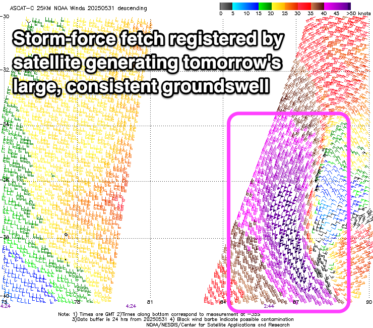
Looking at the source of this groundswell, a strong mid-latitude formed west of Western Australia over the weekend, directing fetches of severe-gale to storm-force S/SW-SW winds towards Indonesia and the Maldives.
Satellite observations picked up the fetch well but the timing has been delayed a little, with the swell due to build through tomorrow, peaking later in the day before easing slowly Thursday.
The slow movement and longevity of the low will result in Thursday likely coming in a similar size to later tomorrow, though with more south in the direction and with less period.
The next increase in swell will be inconsistent, long-range SW energy, generated by a strong but distant frontal progression that took place under South Africa late last week and over the weekend.

An initial, moderate sized SW groundswell for Saturday afternoon and Sunday morning was generated by a tight, intense but short-lived low that fired up late last week, while a broader and more substantial frontal progression moving in behind it should generate a slightly larger SW groundswell for Sunday afternoon and Monday morning.
Sets should reach the large range, though be inconsistent, easing into early next week, though slowed by one final pulse of reinforcing energy Tuesday (under Sunday/Monday’s size)
The next increase in size is due Wednesday afternoon and Thursday morning, produced by a northward located but at this stage, not overly well structured mid-latitude frontal progression moving through this Thursday/Friday.
ECMWF has this system being much more substantial than GFS, bringing larger surf so we’ll have to review the outlook again on Thursday when we have more agreement.
Looking at the local winds and relatively weak E/SE-SE trades are expected to start freshening more into the weekend, becoming stronger next week.
In the Mentawais, the coming swell for tomorrow/Thursday will come in a bit more south while the SW groundswells for the weekend and early next week should have a bit more size compared to Bali.
Variable winds are expected this period, possibly freshening across southern locations from the SE later week. Check back Thursday regarding this.
----------------------------------------------
Maldives:
We should see moderate levels of S/SE trade-swell filling across the regions today, generated by a strengthening and expanding fetch of SE winds south of us.
This fetch is still south of us, maintaining similar sized surf through the rest of the week as the fetch holds until starting to weaken while tracking more east Thursday/Friday.
There’ll also be an inconsistent S/SE groundswell from the stronger low that formed west of Western Australia on the weekend, with this due to arrive later Wednesday but peak Thursday.
Thanks to the weakening trade winds later week, slowly easing levels of trade-swell are due through the weekend and into next week before possibly kicking again mid-late week.
Southerly groundswell wise, the activity south of South Africa should generate good pulses of moderate + sized swell from Friday through the weekend and early next week.
Our current lightish local winds will tip more W/NW through this week while remaining moderate in strength across northern and central locations, freshening over the weekend before strengthening further from the W/SW-SW next week, feeding into an active monsoon trough to our north-east.
Eastern Indonesia:
Large, consistent SW groundswell building tomorrow to 8ft across exposed breaks later, easing slowly from a similar size Thursday morning while tending more S/SW in direction.
Moderate sized, inconsistent SW groundswell building Saturday, peaking into the afternoon and Sunday morning to 4-5ft+.
Larger, inconsistent SW groundswell for Sunday afternoon more to 6ft across exposed breaks, similar Monday morning.
Easing trend slowed by a reinforcing SW groundswell Tuesday.
Large SW groundswell likely Wednesday afternoon/Thursday morning to 6-8ft.
Weak E/SE-SE trades for the coming days, freshening on the weekend and stronger next week (variable offshore each morning).
Uluwatu 16-day Forecast Graph/WAMs
Western Indonesia/Mentawais/South Sumatra:
Large S/SW peaking tomorrow to 8ft across exposed breaks, easing while tending more S’ly later week.
Moderate to large, inconsistent SW groundswell for later Friday but more so Saturday to 4-6ft.
Larger, SW groundswell, peaking Sunday to 6ft to occasionally 8ft across exposed breaks, easing slowly Monday, slowed by a reinforcing pulse into the afternoon.
Large SW groundswell likely next Wednesday to 6-8ft.
Variable winds this period, possibly freshening from the SE across southern locations late next week.
Mentawai 16-day Forecast Graph/WAMs
Maldives:
Moderate sized mid-period S/SE swell for most of this week to 3-5ft across central locations, bigger and to 4-5ft+ across the southern atolls.
Inconsistent S/SE groundswell Thursday morning to 5-6ft across southern atolls, smaller to the north.
Slowly easing S/SE trade-swell on the weekend and early next week.
Inconsistent moderate sized S/SW groundswell from Friday through early next week to 5ft on the southern atolls.
Moderate W/NW winds this week, freshening from the W through the weekend and stronger W/SW-SW next week (weaker to the south).
Comments
Latest notes are live.
Thank you Craig, there’s been some fun waves around lately , not that consistent last few days , when they do come there have been some great pulses . Looking pretty dam good next few days .
Maldives looks set to have a sustained period of good S/SE swell inbound thanks to a stubborn high parking itself pretty much in the entire Indian Ocean.
Question for Craig. Would a negative IOD increase the Wly winds in the Male and Central Atolls? Is there a correlation between IOD and SAM also and what impact this would have on large high pressure systems setting up camp in the Indian Ocean similar to the current one that's forecast? I believe BOM are forecasting a negative IOD soonish?
Don, here's a rough diagram of the link between IOD and the winds in the Maldives.
Effectively, + IOD sees reduced westerly winds, if not swinging easterly through the winter to spring months with - IOD seeing stronger than normal westerly winds flowing from the cooler water off east Africa towards the warm water off Indonesia.
+ IOD brings more SE swell, - IOD less..
I’m not sure that’s correct? On the macro level sure, but locally +IOD is often associated with very strong S to W winds through the chain during large high pressure swell events.
From what what I'm seeing more SE than pure east but not west.
Check this..
"Maps showing the characteristics of strong (upper set) and moderate (lower set) positive IOD events during autumn (September-October-November). Shading indicates that SSTs are warmer (red) or cooler (blue) than average, while the arrows show how the wind stress compares to average conditions."
Thanks Craig for the response and info.
Hey Craig - can you do an article on what Negative IOD means for swell and wind in different regions. Specifically- is there increase in SE swell heading to Maldives and Sri Lanka? It appears to me that the ESE trades west of WA are looking stronger and more consistent this season compared to last few years. We had a strong negative IOD in mid 2022 and that resulted in months of consistent good to great conditions across all the east facing waves of Central and Male atolls
Thanks Craig, very interesting
"The Bureau's model predicts a neutral state of the IOD until at least July after which it forecasts a shift towards a negative IOD. This is consistent with 7 of 8 international models assessed which also forecast a negative IOD pattern developing at some point between June and September. Despite international model agreement, skill for IOD forecasts made at this time of year has been historically low beyond 1 to 2 months ahead." Extract from BOM site