Indonesia/Maldives forecast Apr 29

Indian Ocean Basin analysis by Craig Brokensha (issued Tuesday 29th April)
This week through next (Apr 30 - May 9)
Following the weekend’s increase in S/SW swells, the trend has been down across the region, with a reinforcing mid-period swell slowing the trend into tomorrow morning.
Into the afternoon tomorrow and Thursday morning, the first of two back to back mid-period SW swells are due, generated in our far swell window to the south-east of South Africa last week.
This is only due to generate a small to moderate sized mid-period SW swell with a slightly better increase due later Friday/Saturday from a slightly stronger and broader low that formed south of South Africa last week.
Both will be very inconsistent, but of greater significance is a large run of groundswell due into next week.
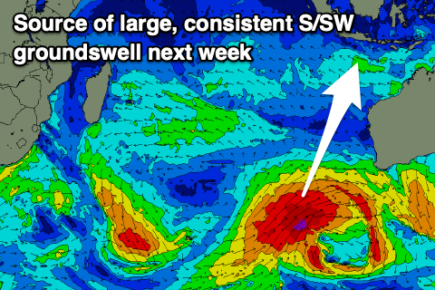
We’re looking at a strong node of the Long Wave Trough forming across Western Australia later this week, with it expected to steer and strengthen a succession of significant polar storms up and towards Australia, through our southern swell windows.
The first system has actually formed as a tight, very intense low to the south of South Africa, with it due to traverse the polar shelf while strengthening from about the Heard Island region Thursday morning. The early stages of this low will generate a very inconsistent SW groundswell for later next week, but the secondary stages are what we’re interested in, with a great fetch of severe-gale to possibly storm-force SW winds being projected towards us Thursday/Friday, breaking down off the Western Australian coast Saturday.
A large, long-period S/SW groundswell is due from this projection, with it due to arrive strongly later Monday but peak Tuesday.

GFS has the fetch stronger than EC bringing more size, but regardless we’re looking at 10ft surf, easing slowly into Wednesday. Secondary weaker frontal activity looks to slow the easing trend into the end of the week with the size unlikely to drop below 6ft until Friday afternoon/Saturday.
The current little burst of trades are due to weaken over the coming days, variable Thursday through Saturday before strengthening from Sunday through next week.
In the Mentawais the swell will come in more south next week but still large next week with variable winds expected over the next week and a half.
----------------------------------------------
Maldives:
A secondary pulse of inconsistent but good SE trade-swell should be in the water today, building towards a peak this afternoon/evening before easing very slowly tomorrow.
With the breakdown of swell generating trades since the swell generation, a slow downwards trend is expected across the central and northern atolls through this week, building again out of the S/SE through the middle of next week thanks to a re-strengthening of the trades south-southeast of us from this weekend.
A peak is likely Wednesday week but we’ll confirm this on Thursday.
Across the southern atolls, the S/SW swell energy from the dual systems firing up south of South Africa should be in the water, with an initial increase this morning ahead of the secondary pulse later tomorrow/Thursday.
The strong frontal progression generating large swell for Indonesia should produce some sideband energy into next Monday evening but more so Tuesday, coming in moderate in size.
Winds look variable over the coming days before taking a S’ly tendency Friday/Saturday, then back to a weak W’ly next week.
Eastern Indonesia:
Small to moderate sized, inconsistent SW swell for tomorrow afternoon/Thursday morning to the 4ft range.
Small to moderate sized, inconsistent SW swell for later Friday/Saturday morning to 4-5ft across exposed breaks.
Large, consistent S/SW groundswell building later Monday, peaking Tuesday in the 10ft range across exposed breaks.
Slowly easing size for the rest of next week.
Weakening trades tomorrow, variable from Thursday through Saturday before freshening again from Sunday.
Uluwatu 16-day Forecast Graph/WAMs
Western Indonesia/Mentawais/South Sumatra:
Small to moderate sized, inconsistent SW swell for tomorrow in the 4ft range.
Small to moderate sized, inconsistent SW swell for Friday in the 4-5ft+ range.
Large, consistent S’ly groundswell building strongly Tuesday, peaking later to 8-10ft across exposed breaks, easing through the rest of the week.
Variable winds.
Mentawai 16-day Forecast Graph/WAMs
Maldives:
Slightly stronger S/SE swell for today and tomorrow morning to 4ft, easing into the end of the week.
Moderate sized S/SW swell peaking this morning to 3-4ft across the southern atolls.
Secondary pulse of S/SW swell Thursday to 4ft+ across the southern atolls, easing slowly into the weekend
Moderate sized S/SE trade-swell building Tuesday, peaking Wednesday to 4ft.
Moderate sized, inconsistent long-period S’ly groundswell for Tuesday to 4ft on the southern atolls..
Variable winds over the coming days, increasing a little from the S’th Friday/Saturday, easing Sunday then weak W next week.
Comments
Latest notes are live.
Thanks Craig, my stomach has butterflies already.
Nice
A Test for Ulus New Sea Wall .
If people didn't talk about it on social media, most people wouldn't even realize it was there. The new development on the cliff is far more concerning.
Fabulous report although looking like I'm going to get blown out soon