Indonesia/Maldives forecast Apr 22

Indian Ocean Basin analysis by Craig Brokensha (issued Tuesday 22nd April)
This week through next (Apr 23 - May 2)
The coming period revolves mainly around the SW groundswell into tomorrow and Thursday, with it expected to bring the most size ahead of a slower run into the start of May.
As touched on through last week, the source was a strong but distant low that formed south of South Africa, piggybacked by a secondary frontal system on top of the active sea state as the progression moved slowly east.
The activity as a whole weakened from about the Heard Island region, leaving inconsistent but strong levels of SW groundswell to spread up and into us, with an arrival set for this afternoon/evening.
The bulk of the swell is due tomorrow though and should build steadily all day, peaking later before easing slowly into Thursday and Friday.
Local winds look variable offshore in the mornings ahead of weak sea breezes over the coming days before E/SE-SE trades kick in later Thursday but more so Friday, weakening a little Sunday/Monday before strengthening into the rest of next week.
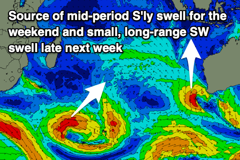
The only other notable swell is for the weekend and the models are over-cooking the size, combining a long–period swell from a healthy polar low with existing mid-period energy.
In saying that we should still see a decent increase in size through Saturday afternoon, generated by the polar low in question, with a good but slim fetch of severe-gale W/SW winds generated just east of the Heard Island region Sunday evening.
The swell looks moderate + in size, likely peaking later in the day Saturday before slowly easing into Sunday.
Also in the mix will be some moderate sized mid-period S'ly swell spawning off a low forming south-west of WA over the coming days. This looks to arrive later Saturday and into Sunday morning.
Otherwise the Indian Ocean goes quiet so make the most of the coming swell.
In the Mentawais the weekend’s N/NW-NW winds are now abating though lingering out of the NW, with more variable breezes due from about Friday.
Swell wise the increase for the coming days will be best, with the weekend’s swell coming in a little south and too late in our swell window to produce any major size.
----------------------------------------------
Maldives:
Over in the Maldives we’ve got a fun pulse of SE trade-swell in the water, mixed in with the large S/SW groundswell across the southern atolls.
Both these sources are due to ease over the coming days before we see a renewal of S/SE trade-swell energy into the second half of the weekend and more so next week.
The source is a healthy fetch of SE trades that have developed south of us, with a couple of intensifications in the fetch extending west of Western Australia due to produce some stronger mid-period swell energy Tuesday afternoon and Wednesday morning.
It looks moderate in size before easing into the end of the week.
Southern atoll wise, we should see some fun S/SW swell energy into the end of next week generated by a low to the south of South Africa this afternoon and tomorrow, with moderate sized sets likely.
Local winds look to be fresh from the W-W/NW this week and weekend, possibly easing a little next week but we’ll review this Thursday.
Eastern Indonesia:
Inconsistent, long-range but moderate + sized SW groundswell building tomorrow, reaching 6ft+ later if not Thursday morning, then slowly easing.
Mix of moderate + sized, inconsistent S/SW swells building Saturday, reaching 4-6ft across exposed breaks, easing Sunday.
Variable tending locally offshore winds ahead of weak sea breezes over the coming days. Weak E/SE-SE trades kicking in late Thursday but more so Friday, stronger next week (variable offshore each morning).
Uluwatu 16-day Forecast Graph/WAMs
Western Indonesia/Mentawais/South Sumatra:
Inconsistent, long-range but moderate + sized SW groundswell for tomorrow, reaching 6ft+ across exposed breaks, easing Thursday.
Small-moderate mix of S’ly swells building slowly Saturday, peaking Sunday to 4-5ft across exposed breaks, easing thereafter,
Lingering winds from the north-western quadrant, more variable from Friday.
Mentawai 16-day Forecast Graph/WAMs
Maldives:
Easing mix of S/SW groundswell and SE trade-swell over the coming days.
Building S/SE trade-swell Sunday to 3ft+, easing slowly Monday.
Slightly stronger S/SE swell for Wednesday to 4ft, easing into the end of the week.
Moderate sized S/SW swell for later Monday, peaking Tuesday to 4ft across the southern atolls.
Secondary pulse of S/SW swell later week to 4ft across the southern atolls.
Fresh W-W/NW winds this week and weekend, easing next week.
Comments
Latest notes are live.
Thanks Craig, appreciate the forecast notes!
Out of interest how accurate is the forecast model for Sumba ?
I notice its saying 2ft most of next week which is a touch smaller than the Uluwatu forecast model.
My understanding is wave size at Sumba should be a decent notch bigger than ulus given the coast faces ssw.
Long story shorter, Im hitting Sumba for 11 days on the 28th April and Im trying to work out whether i need to bring a small wave board or if it'll likely be 3ft+ even on the small days.
Cheers mate
Just spent five weeks there.
Uluwatu forecast model is more accurate.
Depends what you’re interested in surfing, but the waves are either novelty breaks or raw deep water Hawaiian style with not a lot in between.
Not sure where you’re staying but a boat and some local knowledge is the best way around.
Still pretty wet over there when I left a couple days ago. DM me if you want more info.
Thanks for the heads up man. We're staying opposite Kerewe right, pretty close to Nihi, think we have access to boat or 4wd for trips.
Some more info would be great given the lack of for sumba, but don't think can dm on here.
Thanks SF.
Thank you Craig , wind came good this morning up until 11.00 am and waves in the 2-4 ft range , then WSW blew in a storm with consistent rain . Tomorrow morning looks like it could be pumping, hopefully we get an offshore in the morning again .
Thanks Supa.
Well the swell is certainly here solid 6-8 ft maybe bigger, hard to say with nobody out but there has been some bombs coming through. Bad news is the wind is from the north and it had bump and lump on it from last night’s westerly. The hopeful news is this afternoon according to 3 different weather channels has the wind at SE ( offshore ) only 1 local weather forecast is saying SW .
Thanks Supa!
An average size set this morning.