Indonesia/Maldives forecast Apr 15

Indian Ocean Basin analysis by Craig Brokensha (issued Thursday 10th April)
This week through next (Apr 15 - 25)
Our strong pulse of S/SW swell came in well later Sunday and into yesterday, with a less consistent but reinforcing SW groundswell in the water now.
This will ease over the coming days ahead of an inconsistent, long-range mid-period swell for later Thursday but more so Friday.

As touched on last week, the source was a distant and not overly strong polar low that formed south-east of South Africa and only a small to moderate sized, very inconsistent swell is due.
We’re now looking at a fun S/SW groundswell for Saturday, with a strong, tight polar low forming around the Heard Island region yesterday, projecting a great fetch of gale to severe-gale SW winds towards Western Australia before weakening today.
The swell looks moderate to large in size with it due to arrive overnight Friday, peaking Saturday to the 6ft+ range across exposed breaks, easing through Sunday.
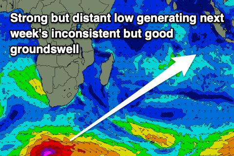
Our next increase in noticeable groundswell will then be another long-range number from the south of South Africa, with a strong low that’s currently moving east generating a great fetch of gale to severe-gale W/SW winds, followed by a secondary slightly weaker fetch piggybacking on top of the initial low.
A moderate + sized but inconsistent SW groundswell should result, with it arriving through Wednesday, building slowly towards a peak later in the day if not Thursday morning.
Local winds are now shifting more westerly as Tropical Low 29 moves slowly west from the North West of Australia, stalling and then weakening through the weekend allowing trades to kick back in.
Winds only look light to moderate NW tending SW tomorrow, then moderate W/NW-NW through the end of the week, easing slowly through the weekend before weak trades start to develop next week (more so later week). Ahead of this more variable winds are due with weak sea breezes.
In the Mentawais we’ve got variable winds due before they freshen out of the NW into the weekend, easing off very slowly through next week and becoming variable later.
----------------------------------------------
Maldives:
We’ve got easing levels of both S’ly groundswell and SE trade-swell across the region, but an uptick in size is due across the southern atolls on Thursday, peaking into the afternoon. This was generated by the mediocre low that formed south-east of South Africa last week, but should provide some fun waves after a lean run.
The building levels of SE trade-swell due from later this week and into the weekend looks to have been downgraded a little with the fetch of SE trades taking their time to develop.
From today we should see a strengthening and expanding trade-fetch spreading across the Indian Ocean with an initial increase in small S/SE swell this weekend due to swing more SE and grow a little bigger into next week. It only looks small to moderate in size, peaking Tuesday before slowly weakening for the rest of the week.
Of greater importance is the S/SW groundswell from the strong low currently passing under South Africa, with a moderate + sized swell due from this source later Monday but more so Tuesday before easing slowly through the week.
Local winds will remain fresh from the W/NW-W this week, especially across the southern atolls before easing Thursday and Friday back to the moderate range out of the W/NW, weaker W’ly on the weekend. W/SW-SW winds may be seen into next week but we’ll review this Thursday.
Eastern Indonesia:
Easing, long-range SW groundswell over the coming days.
Small, inconsistent mid-period SW swell for later Thursday but more so Friday morning to 3-5ft across exposed breaks.
Moderate to large sized S/SW groundswell for Saturday to 6ft+ across exposed breaks, easing slowly Sunday.
Inconsistent, long-range but moderate + sized SW groundswell building Wednesday week, reaching 6ft later if not Thursday morning, then slowly easing.
Light to moderate NW tending SW winds tomorrow, then moderate W/NW-NW through the end of the week, easing slowly through the weekend before weak trades start to develop later week. Ahead of this early next week expect more variable winds with weak sea breezes.
Uluwatu 16-day Forecast Graph/WAMs
Western Indonesia/Mentawais/South Sumatra:
Inconsistent SW groundswell easing over the coming days.
Small, inconsistent mid-period SW swell for Friday to 3-5ft across exposed breaks.
Moderate sized S’ly groundswell building Saturday to 4-6ft, easing from a similar size Sunday.
Inconsistent, long-range but moderate + sized SW groundswell for Wednesday, reaching 6ft+ across exposed breaks, easing Thursday.
Variable winds, tending moderate to fresh N/NW-NW on the weekend, easing slowly next week.
Mentawai 16-day Forecast Graph/WAMs
Maldives:
Small to moderate sized S/SW swell for Thursday to 4ft across the southern atolls, smaller elsewhere.
Small S/SE trade-swell for the weekend to 2-3ft, building more early next week and reaching 3ft to occasionally 4ft Tuesday, easing slowly over then.
Moderate + sized S/SW groundswell building Monday afternoon, peaking Tuesday to 5-6ft across the southern atolls, easing slowly next week.
Fresh W/NW-W winds over the coming days, tending moderate W/NW Thursday/Friday and then lighter W’ly on the weekend. Weak W/SW-SW winds next week.
Comments
Latest notes are live.
Quick one Craig, how long you reckon that long range swell next week will hang around? Is there a few days in it? Doesn't look like much behind it....
I'd say two days of it, that being Wednesday/Thursday.
Cheers Craig, some nice waves yesterday and this morning , bit inconsistent as you predicted but when they came there was some beautiful waves to be had . One very memorable bazza this morning after kooking first two head high waves then getting set on the head. It really turned on for a spell , double overhead sets before tide swallowed it up .
Craig, thanks for forecasts, they've consistently been more accurate than the models I look at. Swell peaked yesterday on the low tide, was 8ish foot and thick. This morning was a bit smaller and less energy.