Indonesia/Maldives forecast Jan 9

Indian Ocean Basin analysis by Craig Brokensha (issued Thursday 9th January)
This week through next (Jan 10 - 17)
With the swell bottoming out, we look towards our small pulse of mid-period S/SW swell into Sunday afternoon but more so Monday across the region.
The source of this swell is a strong but late forming low that developed south-west of Western Australia yesterday, with it since weakening while tracking more south-east.
Fun sized surf is due across eastern Indonesia from this source on Monday before easing slowly Tuesday.
We then look at the much stronger and better SW groundswell due into later Wednesday, with the strong low linked to this swell currently taking shape to the south-east of South Africa.
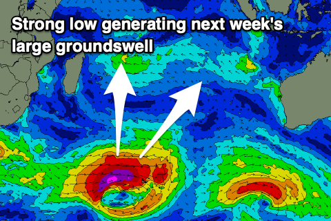
The initial stages of the low should see a fetch of severe-gale to storm-force W’ly winds generated today, weakening slowly through tomorrow while projecting slowly east-northeast towards Western Australia, then breaking down through Saturday.
With the strongest core winds being quite a distance from Indonesia, we can expect large but inconsistent surf into later Wednesday afternoon, peaking Thursday morning before easing off slowly into the end of the week and weekend. The slight projection towards us will be helpful in producing large sets though.
Longer term a secondary pulse of more consistent, large S/SW swell is due Monday the 20th but we’ll look at this next week.
Local winds will freshen out of the W/NW-W from Sunday, persisting Monday before backing off temporarily on Tuesday. We’ll then likely see winds strengthening again from Wednesday, persisting into next weekend.
Over in the Mentawais, the S/SW swell due Sunday/Monday will come in smaller while the SW groundswell should provide similar sized waves to eastern Indonesia into Wednesday afternoon/evening and Thursday morning.
----------------------------------------------
Maldives: Small levels of SE trade-swell seen during the week should increase a touch from tomorrow but exposed breaks will still be mostly small in nature.
This swell looks to ease slowly through early next week as the trades break down, increasing a little from mid-week again as a weak trade fetch reestablishes itself.
Otherwise, the S’ly groundsell for next Tuesday looks the one to target, with it spreading out radially from the same low that’s currently south-east of South Africa.
The swell should build through the day Tuesday and peak into the afternoon, moderate in size before easing slowly Wednesday.
Longer term the secondary pulse of groundswell spawning off another strong but less consolidated low to the south-east of South Africa should arrive later Friday week but peak Saturday.
Looking at the local winds and fresh E’ly winds are due across northern and central locations tomorrow, variable to the south, weaker but more E/SE on Saturday, then back to the E/NE on Sunday.
Variable N winds are then due Monday with fresher N/NE winds across northern and central locations Tuesday, NW to the south. Depending on where a low pressure centre forms mid-next week winds may strengthen further out of the E/NE.
Eastern Indonesia:
Small to moderate sized mid-period S/SW swell for later Sunday, peaking Monday to 5ft across the magnets, easing Tuesday.
Large SW groundswell building later Wednesday to 6ft+, peaking Thursday morning to 8ft across exposed breaks, easing later week.
Secondary large S/SW groundswell likely around the 20th.
Freshening W/NW-W winds from Sunday, a touch weaker Tuesday but then weaker from late week.
Uluwatu 16-day Forecast Graph/WAMs
Western Indonesia/Mentawais/South Sumatra:
Small W windswell fading into the weekend.
Small-moderate sized S’ly swell building Sunday, peaking Monday to 4ft across exposed breaks.
Large S/SW groundswell building Wednesday afternoon to 6-8ft later, easing Thursday from a similar size.
Fresh NW winds, lighter to the north, with winds becoming more variable from Sunday.
Mentawai 16-day Forecast Graph/WAMs
Maldives:
Small SE swell to 2ft tomorrow, possibly reaching 2ft to occasionally 3ft on the weekend and early next week, then easing.
Moderate + sized S’ly groundswell filling in next Tuesday, reaching 4-5ft across the southern atolls through the afternoon, easing slowly Wednesday.
Fresh E’ly winds across northern and central locations tomorrow, variable to the south, weaker but more E/SE on Saturday, then back to the E/NE on Sunday.
Variable N winds Monday, with fresher N/NE winds across northern and central locations Tuesday, NW to the south. Possible strengthening E/NE winds mid-next week.
Comments
Latest notes are live.
Thank you Craig , rains backed off , still a few showers but nothing like December.
Yep in between MJO surges. It's coming.
Came back last night , torrential rain for about 6 hours now. Gotta go bail out the dinghy before it sinks .
East coast will be pumping
Some spots will for sure, but it's got a bit of West in it, lots of the East coast waves like more Southerly swells
Thursday looks very good.
Will be interesting to see what happens on Wednesday with the long period "background" swell.
Hopefully it doesn't rain at the same time as the good tides.
That's the new long-period groundswell on the build.
yep, what i mean is that it will be interesting to see how it translates into waves. Sometimes those swells low height long period swells don't do much, other times they do a lot. I think it comes down to whether they get their period form intensity or from sustained fetch, but just a theory at this stage - will know by Wednesday night.
Agh yeah depends on how long the core winds were at their intensity. I'd expect 6-8ft sets on dark across most exposed spots.
That seems about right for Wed arvo. The models are showing the same size as last Saturday, with an extra 2 seconds of period. Saturday was 4-6 with a few 8 footers. A few spots should be very good, but with a high probability of being washed in at any moment.
Interesting discussion there. May explain why there's those hoax and/or mystery swells in Indo.
Agh yes, that classic one, we've done an article here over a decade ago.. https://www.swellnet.com/news/swellnet-dispatch/2011/04/28/why-swell-tra...
The swell isn't running late or missing, it's just that people and other sites combine the long-period forerunners which generally have no size with the existing swell energy and over-estimate the expected size and get the timing a day off or so.
Our models are pretty good usually at splitting the early stages and not over-forecasting a new swell arrival with exisiting energy.
This is interesting! Sometimes I find indo (Bali swells) depending on their make up can overwhelm (?) some spots or locations. Almost like infagravity waves - swell arrives at shore almost as a tidal push / bulge. When I say this still potentially effected by tides to a degree with high tide obviously effecting this more.. conditions sometimes don’t pump when you expect they would but a lot of water moving about / the surge can be crazy but strangely not working or in general just strange phenomena in the intertidal area..
I experienced a very similar thing once in vicco at a west coast Pointbreak, all available observations would lead you to believe it would be pumping (exceptionally readings and observations) yet all that was observed on shore / inshore was large and wide lumps pushing or surging directly into the shore with limited surf-able waves due to this (if I remember correctly this phenomena occurred on a reasonably low forecast tide however the observed tides where nothing like forecasted.. it was very strange.
I’m pretty sure I discussed this experience / anecdotal observations with Craig at the time and there was a term for the tidal discrepancies / conditions (sorry can’t recall it Craig)
It would be interesting to re-approach
I might add east coast rather than the west.. possibly to do with the Lombok straight
The swell producing low is chunky, later Wednesday will be an easy 8ft now.
Whoop enjoy it ladies & gents. Strongly considering it but have a two & 1/2 year old and another on the way, wifey is 15 weeks but really sick with all day sickness so can’t really fly. Plus I have a very important opportunity at the AO I really should’t burn.. timing is everything. North-ish there would / should be some specific locations on the cook
This is has made my day.
Well I hope it arrives as im making a out of season trip especially
for this forecasted swell leaving Sydney on Sunday mainly because
the east coast hasnt had half decent waves in months.
dang, just read below..
keep yr spirits up best you can while you heal up.
The storm has already blown / is currently blowing, solid swell is a lock.
You will score evo , some of the big name spots the last few swells haven’t even been that crowded . The tamer waves on the east coast have been packed with euros, Japanese and Koreans . Enjoy
@evo , can you bring some sunshine with you ?
Supafreak its been raining in Sydney the last 4 days
whats the forey lookin like on the ground for the last two weeks of jan supa?
Do you mean the weather forecast ? I get 10 day forecast off a few different weather channels but they really aren’t very accurate . A normal wet season ya get rain through the night, a scud or 2 in the morning and afternoon but this season has had days where it just hasn’t let up . Wind has also been up lately . Next few days are forecast to be cloudy with odd shower and the days it’s going to be pumping look windy but not torrential rain . Again their forecasts aren’t great . The water table is getting a much needed top up after a relatively mild wet season last year .
Plane, accommodation and transport all booked 4 boards accessories and clothing packed
super excited to surf pumping off shore Nusa Dua with back to back swells for 10 days
especially after 3 months of no surf and bingo on day of travel my back blows OUT.
History im done cancelled everything 3 hours before take off. Pissed off understatement.
Ah man that sucks.
Oh man that really sucks, I was going to reply with have a great trip until I read the back blowout bit . You would be understandably shattered. Here’s to a speedy full recovery. I remember reading once before you saying you only had so many years left to keep charging and wanted to make the most of it before age took its toll on your body . Chin up mate , best wishes on the recovery road .
Ah man that's heavy...
Bad luck, hope ya have a quick recovery. Love wet season Nusa.
Nooo! Bummer :(
Oh fark mate. Thats farked (excuse my French)
Speedy recovery mate get down the Oesto for some cupping needling and treatment - those guys and girls can work magic and quickly
At least hopefully a speedy recovery and some waves on home shores / locales
Thanks boy im shattered. Looks like old age has caught up out of nowhere.
You don't surf like an old man Evo. Heal up mate.
Where did I read Kellys right somewhere on here… ol’ mate and his helicopter ffs