Indonesia/Maldives forecast February 27

Indian Ocean Basin analysis by Craig Brokensha (issued Tuesday 27th February)
This week through next (Feb 28 - Mar 8)
Following the weekend’s pulse of mid-period S/SW swell, we’ve got a mix of background S and S/SW swells for the coming week, hovering in the 4ft range across the exposed magnets from today through Friday.
As touched on last update, things get more exciting into the end of the week and weekend as some better pulses of S/SW swell fill in.
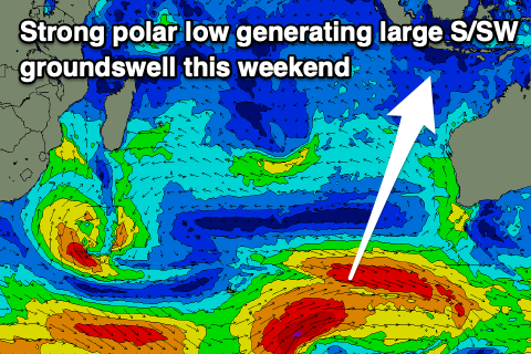
An initial increase Friday afternoon will be mid-period energy, generated by a healthy frontal system that developed on the weekend, south-west of Western Australia ahead of a stronger polar low. The low should generate a great fetch of stronger gale to severe-gale W/SW winds and a larger S/SW groundswell that’s due to fill in Sunday.
A trailing polar front firing up behind the polar low should generate a reinforcing S/SW groundswell with lesser size for early next week, slowing the easing trend, then easing into the end of the week.
After this, the next round of swell looks to arrive the following weekend again. We’ll have a closer look at this on Thursday.
Across to the Maldives and small levels of S/SE swell that are currently in the mix should continue through the week, with groundswell from the polar low due to arrive into Sunday, followed up by some good, mid-period S’ly swell through early-mid next week.

The source of the mid-period swell is a mid-latitude low/trough forming south-southeast of Madagascar later this week, directing a slow moving fetch of strong S’ly winds through until Friday. This should generate moderate levels of swell that should persist until Wednesday before easing.
Eastern Indonesia:
Background S-S/SW swells for most of this week to 4ft across exposed breaks.
Inconsistent, mid-period S/SW swell filling in Friday, reaching 4-5ft across exposed breaks into the afternoon, easing from a similar size Saturday.
Larger, S/SW groundswell for Sunday to 6-8ft across exposed breaks, easing Monday.
Reinforcing, moderate-large sized S/SW swell Tuesday to 4-6ft across exposed breaks.
Variable winds most of the period tending more W/NW-W/SW on the weekend.
Uluwatu 16-day Forecast Graph/WAMs
Western Indonesia/Mentawais/South Sumatra:
Mixed S’ly swells for this week to 4ft across exposed breaks.
Moderate-large sized S’ly groundswell for Sunday to 6ft, easing Monday and slowed a little into Tuesday.
Variable winds, tending N/NW-NW Friday afternoon and freshening through the weekend, holding early next week.
Mentawai 16-day Forecast Graph/WAMs
Maldives:
Small S/SE swells this week to 2-3ft or so across the southern atolls.
Small NE windswell also in the mix.
Moderate sized, inconsistent S’ly groundswell building Sunday afternoon, reaching 4ft across the southern atolls.
Reinforcing mid-period S’ly swells to 4ft across the southern atolls Monday through next Wednesday
Easing E/NE winds into tomorrow, variable Thursday, then tending E/NE-E into Friday. NE winds persisting through the weekend, tending lighter N/NE early-mid next week.
Comments
Latest notes are live.
Thanks Craig , getting fark all on the rock , too south I think, went over to the east coast bali a few days ago , nice swell but packed where I was , 30 + guys. Swell coming looks good.
Roger that. Cheers Supa and this weekend looks the goods!