Indonesia/Maldives forecast January 23

Indian Ocean Basin analysis by Craig Brokensha (issued Tuesday 23rd January)
This week through next (Jan 24 - Feb 2)
A small lift in inconsistent SW groundswell was seen on the weekend but this has since eased back in size and strong winds from the western quadrant are limiting surfing options.
Over the coming week, nothing significant is due, with weak, background levels of mid-period S/SW swell due from funky sources off the west coast of Western Australia.
Strong S’ly winds over the coming days should produce the most size through Thursday/Friday but only to 4ft on the south magnets in eastern Indonesia, though smaller east of Bali.
There’ll also be average levels of W’ly windswell in the mix from strong, persistent monsoonal W/NW-W winds that will start to weaken later week but more so into the weekend.
Into the weekend, some stronger and better S/SW groundswell is due across the region, generated by a healthy frontal system that’s currently projecting towards the south-west of Western Australia.
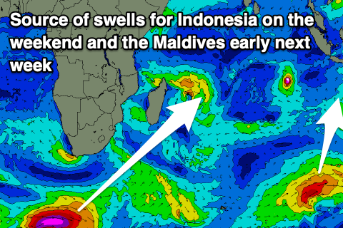
A fetch of strong SW winds with embedded gales should generate a moderate + sized swell for later Saturday, peaking Sunday morning.
The swell will be smaller to the west, with it easing back through later Sunday, further into next week.
Longer term the outlooks is a bit wishy washy with the Indian Ocean stacked with activity though mostly tropical lows and cyclones, no good for swell generation across Indonesia.
We might see a weak frontal progression generating a weak S/SW swell later next week but more on this Thursday.
Coming back to later this week across the Mentawais, and some funky W/SW swell from a stationary fetch of strong winds directly north-east of Madagascar is due Thursday afternoon and Friday, but the source now looks weak. It’s not worth really noting.
The Maldives are currently seeing a mix of E/NE windswell and background SE trade-swell with no new swell sources due until early next week.
That will be in the way of S’ly groundswell, generated by a strong but tight polar low that’s currently south of South Africa.
A polar fetch of gale to severe-gale W/SW winds are being generated, with the low due to project north-east while weakening over the coming days. A moderate sized swell is due from this source, peaking Tuesday with some cyclone swell also in the mix.
Eastern Indonesia:
Small mid-period S’ly swell over the coming days, peaking Thursday afternoon and Friday to 4ft across exposed breaks, easing into the weekend.
Strong W/NW-W winds, easing into the weekend and tending W/NW-NW in the mornings.
Moderate + sized S/SW groundswell arriving Saturday afternoon, peaking Sunday morning to 6ft across exposed breaks (possible rare bigger one), easing later and into next week.
Uluwatu 16-day Forecast Graph/WAMs
Western Indonesia/Mentawais/South Sumatra:
Small, weak S/SW swell over the coming days.
Smaller, inconsistent, mid-period W’ly swell arriving later Thursday, peaking Friday, easing thereafter.
Moderate sized S’ly swell for Sunday to 4-5ft across exposed breaks, easing into next week.
Weak SE tending S/SE winds tomorrow, Thursday and Friday, tending more variable Saturday and then NW from Sunday through Tuesday next week. Variable winds thereafter.
Mentawai 16-day Forecast Graph/WAMs
Maldives:
Weak E/NE windswell this week with fresh to strong E/NE winds, tending more NE across southern locations.
Winds strengthening late week, persisting on the weekend, generating a little more windswell energy.
Small SE trade-swell to 2ft to occasionally 3ft also in the mix over the coming days.
Moderate sized S’ly groundswell for later Monday, peaking Tuesday to 4-5ft across the southern atolls, slowing easing thereafter.
Comments
Latest notes are live.
Appreciated Craig , thank you