Indonesia/Maldives forecast December 21

Indian Ocean Basin analysis by Craig Brokensha (issued Thursday 21st November)
This week through next week (Dec 22 - 29)
A good, though inconsistent S/SW groundswell filled in yesterday across Indonesia, with it backing off slowly today as SW winds add bumps to the marquee Bukit reefs, cleaner across other options.
The trend will be slowly down over the coming days, bottoming out Sunday morning ahead of a small pulse of background mid-period S/SW swell into the afternoon.
No major size is due but it'll boost wave heights slightly into the afternoon/evening, and Monday, easing thereafter.
Our slightly better, inconsistent groundswell for Tuesday/Wednesday is on track, with a slow moving low through the Southern Ocean generating strong to at times gale-force W/SW winds.
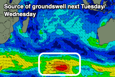
The persistent nature of the low should generate some fun, inconsistent SW groundswell that's due to build Tuesday, peaking later, then easing slowly Wednesday and further into the end of the week.
Longer term, a moderate sized, inconsistent SW groundswell is possible for Sunday/Monday the 31st/1st. We'll have a closer look at this on Tuesday though.
Our current weak SW winds are due to ease mid-late next week and switch back to the SE on Thursday/Friday next week, even fresher E/SE into next weekend. We'll confirm this in the next update.
Looking across the Maldives and we've got a mix of S'ly pulses of weak NE monsoon swell from persistent, strong E/NE-NE winds setting up camp across Sri Lanka, gaining the most strength through next week.

This will bring locally tricky and poor winds for east facing breaks across the central and northern atolls, more variable to the south.
The first pulse of S'ly swell is due tomorrow afternoon, easing into Saturday with a slightly stronger pulse of S'ly groundswell late Sunday.
Following this mid-period S'ly swell looks to persist through the week, peaking Tuesday/Wednesday, easing slowly through Friday.
The E/NE-NE swell looks to come in at 3ft or so across northern and central locations next week, smaller to the south.
Eastern Indonesia:
Easing S/SW groundswell today, further tomorrow and Saturday.
Small, background mid-period S/SW swell for Sunday afternoon and Monday morning to 4ft across exposed breaks.
Inconsistent SW groundswell building Tuesday, reaching an inconsistent 4-5ft+ across the magnets, easing Wednesday from a similar size.
Possible similar sized, inconsistent SW groundswell for Sunday/Monday the 31st/1st.
Light, variable winds most of the period, tending SW-S/SW into the afternoons, tending SE next Thursday/Friday into the afternoons, E/SE the following weekend.
Uluwatu 16-day Forecast Graph/WAMs
Western Indonesia/Mentawais/South Sumatra:
Easing S'ly groundswell over the coming days.
Small, inconsistent mid-period S/SW swell Sunday to 3ft+, easing Monday.
Inconsistent SW groundswell for next Tuesday to 4-5ft on the swell magnets, easing. Possibly similar sized SW groundswell the following weekend.
Variable winds this period, tending S/SE-SE across southern locations later next week.
Mentawai 16-day Forecast Graph/WAMs
Maldives:
Inconsistent S'ly groundswell building tomorrrow to 3ft+ across the southern atolls, smaller Male. Easing swell into the weekend.
Small, weak SE trade-swell building this week, along with E/NE-NE windswell, more so into the weekend and next week to 3ft across northern and central locations, smaller to the south.
Moderate sized, inconsistent S'ly groundswell building Sunday, peaking Monday to 4ft+ across the southern atolls.
Reinforced mid-period S'ly swell for Tuesday/Wednesday more to 4-5ft across the southern atolls, easing later week.
Moderate to fresh E/NE-NE winds over the coming days, more variable to the south.
Stronger winds kicking in from E/NE are due on Sunday and Monday, more so Tuesday onwards.
Comments
Latest notes are live.