Back to back XL groundswells

Hawaii North Shore, Micronesia and PNG forecast by Craig Brokensha (issued on Thursday 13th December)
Best Days: North Shore early Thursday, Sunday, Monday, Thursday week - Micronesia Friday through Monday and then Wednesday, PNG every day
This week and next (Dec 14 - 21)
Hawaii: A slow start to today but with some new inconsistent NW groundswell, building to a stronger and on forecast 6ft+ later this afternoon but with strong trades and long waits.
The swell is expected to drop through tomorrow from 4-6ft on the sets, though lully, smaller into the afternoon.
A small mid-period NW swell is due to fill in through Friday keeping 3-5ft sets hitting the regional magnets, easing slowly through Saturday.
 We'll see winds remain strong and gusty tomorrow from the E/NE, easing off very slowly through Friday and Saturday.
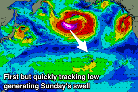
We've had a further upgrade in the strength and scope of a very significant storm that's currently forming east of Japan.
A broad low is deepening, with a fetch of severe-gale to now storm-force W/NW winds due to be generated as the low moves quickly through our north-western swell window.
As the low pushes further east it will broaden in scope, and we're expecting to see an XL NW tending N/NW groundswell for Sunday, with long-period forerunners in excess of 20s due to show late Saturday, likely kicking the surf to 4-5ft.
 Sunday is now expected to come in at an easy 15ft across the North Shore, if not for the odd bigger cleanup, easing through the day under great E-E/NE trades. Monday will also be great as the swell continues to ease from the 10ft range on the sets.
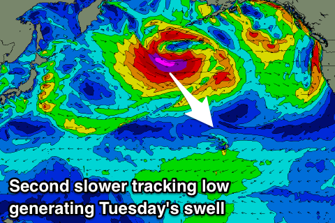
The secondary strong low is still on track, with it forming a touch later in our swell window but moving much slower and projecting more towards us.
We'll see a fetch of severe-gale to storm-force W/NW winds projected through our north-western swell window, with a secondary push south-east through our northern swell window.
Another XL NW tending N/NW groundswell is expected, arriving Tuesday morning and building to a similar 15ft+ or so later in the day but with poor and strengthening N/NE winds. The swell will ease slowly through Wednesday with average N/NE tending NE winds, cleaner and easing quickly from 8-10+ Thursday morning.
Longer term a new long-period, oversized W/NW groundswell is on the cards for next weekend, but we'll have a closer look at this next Tuesday.
North Shore Forecast Graph
North Shore WAMs
Micronesia: We didn't see a typhoon form in the established trade-flow, and instead the tropical depression has generated a slight kick in stronger NE swell for the region but under the expectations from Tuesday.
A relaxation of trades tomorrow, swinging more E/SE should open up the northern reefs passes for some fun waves tomorrow, smaller and easing through Saturday.
Our variable winds for Sunday and Monday mornings are still on the cards with the easing trade-swell, providing options on those east facing reef passes.
Small levels of E/NE trade-swell will persist through the rest of the period, though the strong lows developing north-west of Hawaii should also generate small pulses of N'ly groundswell.
The first low isn't great, with no size expected into Monday, but the secondary low should produce a small N'ly groundswell to 3ft on the sets Wednesday. Longer term the storm generating the W/NW groundswell for Hawaii next weekend will form more favourably in our swell window, with a good increase due into Sunday/Monday the 23/24th, but more on this next update.
Palikir Pass Forecast Graph
Palikir Pass WAMs
Papua New Guinea: Our persistent run of NE trade-swell should continue in the 3ft+ range into the end of the week, with the pulse for the weekend from the tropical depression due to come in more around 4ft on the sets, building Saturday and peaking Sunday.
A slow drop in size is then due into next week and winds look favourable and variable each morning with afternoon sea breezes.