N/NE swell for Friday, with a small W/NW swell mid-next week

Hawaii North Shore, Micronesia and PNG forecast by Craig Brokensha (issued Thursday 13th November)
Best Days: Northerly swell friendly breaks Friday and Saturday, Wednesday
This week and next (Nov 10 – 17)
Hawaii: The surf's bottoming out across the North Shore today, with tiny waves due into tomorrow.
Our new N/NE groundswell for Friday is still on track with a strong low forming south of Alaska, projecting a fetch of gale-force N/NW winds through our northern swell window the last couple of days.
The swell should build through the day and peak into the afternoon to 6ft to occasionally 8ft across northerly friendly breaks.
 A slow drop is then due through Saturday from 4-6ft, smaller into Sunday and early next week.
E/NE trades will create clean conditions across the North Shore, though more exposed breaks to the N/NE swell will be a bit wind affected.
Our moderate sized north-east trade-swell for next week has been downgraded, with only a small kick in swell due through the middle of the week out of the N/NE to the 3-4ft range.
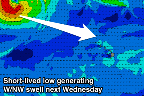
A new mid-period W/NW swell is due though, produced by a small and short-lived burst of strong to gale-force W/NW winds towards us over the weekend.
An increase in size is due from dark Tuesday, with the swell peaking Wednesday morning to 4-5ft on the North Shore, easing back into the afternoon and further Thursday.
Gusty E/NE-E trades will create clean but blowy conditions.
Longer term there's nothing major on the cards with a blocking setup across our north-western swell window persisting into next week. When this breaks up is still unknown, but we'll have another look at this Tuesday.
North Shore Forecast Graph
North Shore WAMs
Micronesia: A small to moderate sized NE trade-swell should be breaking across exposed breaks to the north-east today, coming in around 4ft but easing later today and further into tomorrow and the weekend.
The only other swell due through the period is expected to arrive from the N/NE through early-mid next week.
This will be produced by a weak front projecting down towards us into the weekend, generating some weak N'ly swell for Tuesday, building to 3-4ft or so at north facing breaks, with some small N/NE groundswell from the weak low also in the mix.
This swell should ease back into Wednesday, smaller Thursday. E/NE trades will kick up a little limiting the best waves to slightly protected breaks.
Palikir Pass Forecast Graph
Palikir Pass WAMs
Papua New Guinea: Not much to talk about for the PNG region this coming period with light variable winds and small background swells to 2ft to occasionally 3ft at exposed breaks to the north-east today through Saturday.
The swell will then drop back from here and remain small for most of the period. Hopefully things change in a week or so.