Large back to back swells across the North Pacific

Hawaii North Shore, Micronesia and PNG forecast by Craig Brokensha (issued Thursday 23rd March)
Best Days: North Shore tomorrow and Friday morning, later Saturday onwards for experienced surfers, Micronesia over the whole period, PNG similar
This week and next (Mar 24 – 31)
Hawaii: Easing surf yesterday morning, but a reinforcing NW pulse arrived into the evening, and has kept good sized 4-5ft+ sets hitting the North Shore this morning.
We'll see this swell slowly easing over the coming days, down from 3-5ft tomorrow morning, and 3-4ft Friday morning with E'ly trades.
The swell will bottom out through Saturday morning, but as indicated Tuesday, a long-period XL groundswell should kick very strongly later in the day ahead of a peak through Sunday.
This swell has already started to be generated by a vigorous low east of Japan, with satellite observations confirming a fetch of storm-force W/NW winds through our far western swell window.
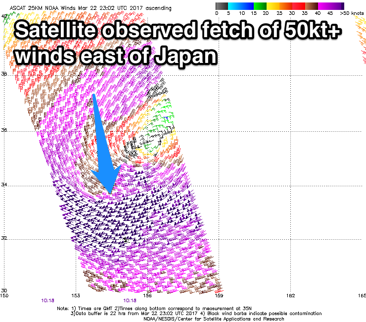 The low is moving slowly east towards us while expanding in scope and easing slightly in strength but maintaining severe-gale to near storm-force W/NW winds. The low will also drift slightly more into our north-west swell window.
An XL W/NW groundswell will be created, kicking strongly later Saturday to 6-8ft ahead of a peak Sunday to 15ft at reliable westerly swell magnets.
The easing trend will be slow and from the NW, with easing 12ft+ waves Monday morning, down further from 6-8ft Tuesday morning.
Into Wednesday we'll see another large NW groundswell pulse from a secondary low forming off the Kamchatka Peninsula this weekend.
We'll see a broad fetch of severe-gale W/NW winds aimed towards us, producing a long-period NW groundswell for Wednesday, kicking back to 8-10ft before easing into the afternoon and further Thursday.
Yet another large groundswell is on the cards for the end of the week, with a small intense low spawning off Japan and moving east towards us through our western and then north-western swell windows.
We're looking at 10ft of groundswell building into Friday afternoon, but we'll review this Wednesday.
Conditions over this period are looking great with increasing E'ly trades this weekend, weaker Monday and then fresh and gusty from Tuesday again next week.
North Shore Forecast Graph
North Shore WAMs
Micronesia: We should be seeing a good N'ly groundswell pulse this afternoon, offering 3-4ft sets before easing back through tomorrow.
The vigorous low off Japan generating Hawaii's XL swell will produce a large and powerful N/NW groundswell for Micronesia this weekend, kicking very strongly Saturday to 6ft through the afternoon with 8ft sets likely by dark.
A slow easing trend should then be seen Sunday from 6ft, down from 4-5ft Monday.
Conditions will be great for these north facing breaks with gusty E/NE winds, easing mid-late next week.
The reinforcing NW swell on the North Shore will be generated too far east out of our swell window, but the second small intense low forming off Japan will produce a good N/NW groundswell for Friday and Saturday week.
North facing breaks should kick to 3-4ft+ and hold Saturday, easing Sunday.
Palikir Pass Forecast Graph
Palikir Pass WAMs
Papua New Guinea: The reinforcing N'ly swell impacting Hawaii and Micronesia today will fill in tomorrow across our region, offering inconsistent 2-3ft sets, easing off into the weekend.
The larger N'ly groundswell is due to fill in Sunday and reach 3ft by late in the day, with 3ft to sometime 4ft sets Monday morning, easing slowly through the rest of the week.
Some small E/NE trade-swell should also be in the mix as the N'ly groundswell eases, coming in Wednesday through the following weekend to 2ft to occasionally 3ft.
Conditions through the period look great with variable winds for the most part each morning with afternoon sea breezes.