Easing clean surf, with some new swell from Sunday

Hawaii North Shore, Micronesia and PNG forecast by Craig Brokensha (issued Thursday 16th February)
Best Days: North Shore Thursday, Friday, Saturday morning, Monday, Tuesday morning, later next week. Micronesia tomorrow, next weekend onwards, PNG Sunday onwards
This week and next (Feb 16 - 24)
Hawaii: An XL swell is currently easing across the North Shore and it will continue to do so over the coming days (10ft tomorrow morning) with fresh E/NE trades kicking back in through the day tomorrow, lighter into Friday and Saturday morning.
A small low pushing down towards us late week and weekend will clip the islands and bring a strengthening NW'ly breeze Saturday evening, tending back to the NE on Sunday and then to more favourable E/NE trades by Monday.
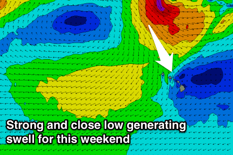 A large NW tending N/NW swell should also arrive from this low, building through Sunday and easing off slowly Monday.
With the close proximity and a fetch of NW gales projected towards us, we should see the North Shore building to the 8ft+ range into the afternoon, easing from a similar size Monday but from a more northerly direction.
Come Tuesday smaller and fading 3-5ft surf is due.
Into the end of the week a mixed NW groundswell is due from a broad but unconsolidated frontal system pushing east off Japan.
A mix of strong to gale-force winds will be projected towards us, with a moderate to large sized swell resulting, peaking Thursday around 6-8ft.
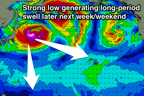
A much stronger but more distant low should form off Japan early next week, projecting a fetch of severe-gale to storm-force W/NW winds through our far western swell window.
This should produce a large long-period W/NW groundswell for Friday, building through the day and peaking into the afternoon around 8ft+ before easing back into Saturday with fresh to strong E/NE trades.
Beyond this there's nothing significant on the cards so make the most of the coming swells.
North Shore Forecast Graph
North Shore WAMs
Micronesia: Large surf was seen through yesterday and this is now continuing to drop with it fading further tomorrow from 2-3ft.
 The storm activity over the coming week will be too far east or north, out of our swell window and we'll just see small moderate amounts of E/NE trade-swell across the coast.
This swell should really muscle up through the weekend, peaking Sunday to 4-6ft at exposed breaks to the north-east before tailing off slowly through next week.
The groundswell impacting Hawaii later next week will filter down to us, with the secondary pulse being great for our region. We're looking at 4-5ft surf Friday evening and Saturday, but we'll review this on Tuesday.
Fresh to strong E/NE trades are due over the coming days easing back slightly early next week but not enough to open up exposed breaks for a surf.
Palikir Pass Forecast Graph
Palikir Pass WAMs
Papua New Guinea: Some fun sized N/NW groundswell should be breaking on the coast today and we'll see this swell fading this afternoon, down further from an inconsistent 2ft+ tomorrow morning.
The trade-swell impacting Micronesia should build through Sunday, reaching 3-4ft, possibly with the odd bigger one Monday before tailing off very slowly through the rest of the week.
We then look towards the inconsistent N'ly groundswell for next weekend, but more on this Tuesday.
Variable winds should continue for the most part across the region each morning, taking a slight tendency to the west next week.