XL swell to end the week, another very large swell for Monday

Hawaii North Shore forecast by Craig Brokensha (issued Thursday 10th November)
Best Days: Every day till Wendesday for experienced surfers in Hawaii, Micronesia Friday through Wednesday, PNG, Friday through Monday
This week and next week (Nov 11 - 18)
 Hawaii: The XL N/NW groundswell seen at the start of this week has continued to ease off through today with clean conditions this morning and weak sea breezes this afternoon.
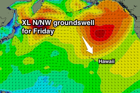
Into tomorrow, our new mid-period N/NW swell is still on the cards ahead of a very late kick in new XL N/NW groundswell, peaking Friday morning.
The mid-period swell was generated by a small embedded low at the head of a much more significant and sustained fetch of severe-gale NW winds, linked to Friday's swell.
Exposed breaks should offer surf in the 6ft+ range on the North Shore most of the day, with a late afternoon kick in size due, reaching 12ft+ or so by dark.
Friday morning should reveal the most size with 12-15ft sets, maybe the odd bigger bomb at outer reefs, easing steadily through the day and further through the weekend.
Conditions from tomorrow should be good through the morning with weak afternoon sea breezes, then light E'ly trades Friday and Saturday, slowly freshening into Sunday, stronger early next week.
The large NW groundswell for early next week is still on track, with even a slight upgrade in size.
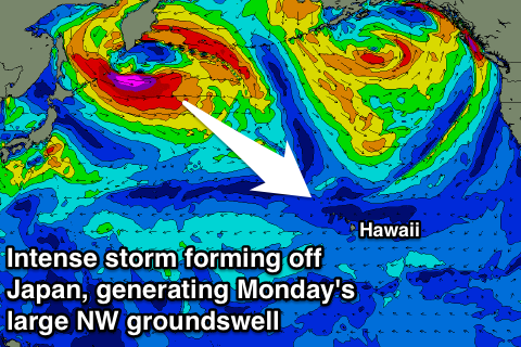 An intense low pressure system is forecast to form off Japan tomorrow, projecting a fetch of severe-gale to storm-force W/NW winds towards us while weakening and shrinking over the coming days.
This should produce an inconsistent but very large NW groundswell arriving after dark Sunday and filling in overnight, peaking Monday to 12-15ft, with the possibility of the odd bigger bomb, easing into the afternoon.
From here on we'll see the surf drop away steadily, down from the 8ft range Tuesday, much smaller into the rest of the week.
Fresh to strong E/NE trades will continue through next week, possibly intensifying further into next weekend.
Longer term some mid-period N'ly swell may be seen next weekend, but more on this Tuesday.
North Shore Forecast Graph
North Shore WAMs
Micronesia: Our N/NW groundswell for later today and tomorrow from the remnants of Typhoon Meari is still on track, with exposed breaks to the north due to see 4-5ft sets tomorrow morning.
The swell will then fade into Saturday and further Sunday with only a small and inconsistent pulse of N'ly groundswell for Monday from the low forming off Japan on Monday afternoon.
Exposed breaks should come in at 3-4ft Monday afternoon, if not for the odd bigger one, easing back into the middle of the week.
Longer term a small mix of N'ly and E/NE swells are due into the end of the week with some possible larger NE trade-swell late next weekend.
Palikir Pass Forecast Graph
Palikir Pass WAMs
Papua New Guinea: There's no change to the N/NW groundswell due through the end of the week. A building trend is due tomorrow, with inconsistent 3ft sets showing at exposed breaks to the north later tomorrow, holding Saturday before easing Sunday.
Longer term there's nothing significant at all with a small mix of N'ly and E/NE swells.