Back to back XXL swells for next week

Hawaii North Shore forecast by Craig Brokensha (issued Thursday 21st January)
This week and next (Jan 22 - 29)
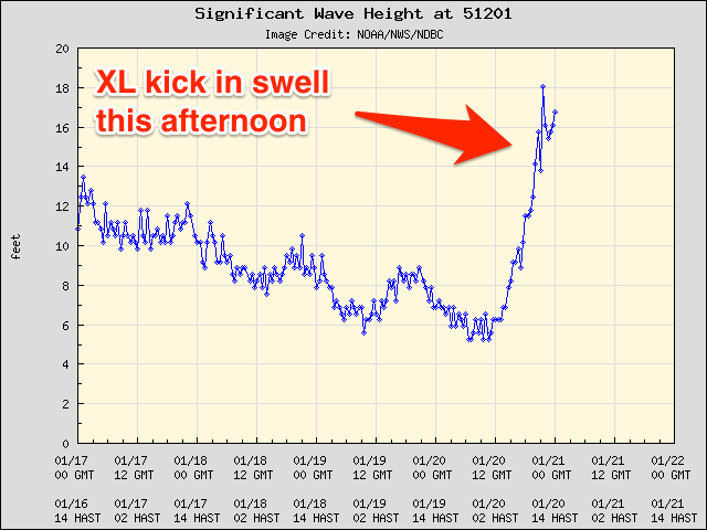 The surf on the North Shore eased back through yesterday and bottomed out early this morning. Since then, a very rapid increase in swell has been seen with the arrival of an XL event.
Today the Waimea buoy has rocketed up to 18ft (5.4m) at 18 seconds (right). This should result in an expected kick in size to 15-20ft across selected breaks across the North Shore with moderate N/NE winds.
The 51101 buoy has since eased, and this trend should be seen across the North Shore 10 hours later, with a drop in size due through this evening, further down through tomorrow from 12-15ft at dawn across selected breaks on the North Shore.
Winds should improve and swing around to the E/NE, persisting Friday as the swell continues to fade from 4-5ft early at swell magnets. The swell will bottom out into Saturday with variable winds and afternoon sea breezes.
As touched on last update, from Sunday we're due to see a sustained period of XL-XXL surf, climaxing through Wednesday and Thursday.
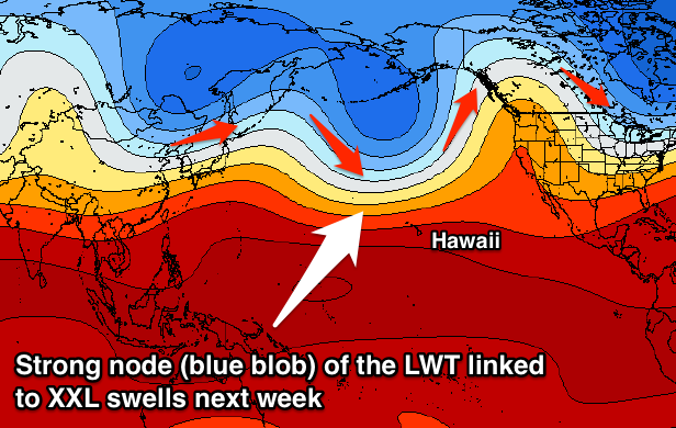 This will be related to a strong node (peak) of the Northern Hemisphere Long Wave Trough strengthening through the North Pacific Ocean over the coming week. The Long Wave Trough essentially steers and strengthens storms along the path and towards where it is focussed, which will be Hawaii (shown right).
Initially a broad and slow moving low pressure systems that's spawned off Japan will move east, with smaller embedded lows spinning anti-clockwise within the main structure.
A persistent fetch of severe-gale W/NW winds will be projected towards Hawaii as the system as a whole approaches the islands over the coming days, generating numerous pulses of XL surf from later Sunday through Tuesday.
Sunday's initial increase will be the least consistent due to it being generated the furthest away, with a slow increase to the 12-15ft range due later in the day.
A secondary larger NW groundswell is due through the evening, offering 15-18ft surf early Monday morning ahead of a the largest most consistent kick in NW groundswell through the middle of the day. This will be generated as one of the embedded fronts projects right down towards Hawaii, kicking the surf to the 20ft+ range into the afternoon.
A drop in size is then expected through Tuesday from 15-18ft or so.
Conditions on Sunday morning are due to be good, but as the new swell kicks, poor and fresh W/NW winds are due as the front pushes down close to Hawaii, with easing N/NE tending E/NE winds through Monday. Tuesday looks to see increasing Kona SW winds, as the storm linked to the next XXL swells muscles in.
 Wednesday/Thursday's swell is one to behold, have a quick run through the WAMs and watch the charts light up all kinds of purple and white!
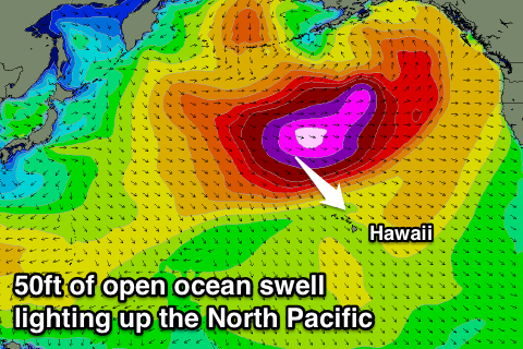
This swell will be generated as the the Long Wave Trough reaches peak intensity, resulting in the creation of an all encompassing North Pacific storm with severe-gale to storm-force winds stretching over some 2,500km.
Open ocean swell heights are due to reach just under 50ft, with an XXL long-period swell produce for Hawaii, filling in Wednesday and reaching 25-30ft across the North Shore, with larger waves at offshore deep water reefs.
Conditions are questionable with fresh but easing SW winds, although we'll have another look at this on Tuesday.
Comments
Looks like the Eddie may already be on "watch and act" (to borrow a fire alert phrase) for next week's swell. Fingers crossed!
Gulp. Was scary enough in the water today!
Ha, mad man Whitey!
What day will be the possibility of all day 20ft ?
lets hope that wind co-operates.
Thursday possibly ? But bigger in morn dropping in arvo
Yeah, if any day it has to be Thursday, swell arriving through arvo Wednesday and wouldn't qualify for their 8 hours 20ft+ criteria.
The only issue is that the later heats will be held in smaller surf. Split days?
Who cares ! Jaws will be on anyway
Haha, um you were the one who asked.
No offence craig , that read differently than it sounds . I meant well I dont care if the eddie doesnt go because of the possibility that the criteria isn't reached . And jaws will be huge again so thats all that matters . Ie raising the bar , which wont occur at da bay
Ah, yep got ya, cheers!
Howsabout they move the Eddie to Jaws?
Yeah, I know, there's the whole 'tradition' thing, the bay calls the day and all that. But we've gotta be flexible on these matters, and after all the very first Eddie was held at Sunset Beach.
Make the Eddie mobile!
That seems the go now, with Waimea just not looking that impressive when comparing it to maxing Peahi.
If they want to keep it as the most prestigious (big wave) event in the world for the coming generation, they will have to. Having the first event at sunset and the fact Eddie was born on Maui? sure makes it easy enough. Do the WSL have anything to do with the event? Conflicting with the BWWT is an issue. Eddie & BWWT Peahi just need to merge, and they will have the stand alone premier event.
Forecasts for the swell later week have unfortunately been downgraded, with the storm keeping further north and not looking anywhere near as expansive or strong.
Bummer thats fucked ! At least mark mathews will be a bit happy about it . So no sign of Eddie ?
Swell downgraded still to a night time eddie swell , quiks dodged it
Yep.
Craig, caml, anyone,
Does Jaws get shielded somewhat if the swell has a lot of west in it. Of course big period swell will bend in, but Maui has Molokai and Oahu to it's west/northwest, so just wondering whether more north is betterer for Peahi.
Yeah, it gets shadowed, but the islands to the west.
yep NNW is prime for Jaws.
Waimea likes more W to NW
Still looking massive IMO. I'm surprised they've called off the Eddie so far ahead. Could easily see it kicking in through the morning. Arvo will be huge!
Even a nw swell is good jaws & might be better for the west bowl albee zone . And thats still not shadowed . Ben the swellmet forecast has it biggest thurs am right ? What arvo do u mean ?
Ah rightyo latest updated cast has weds arvo the peak now not thurs morn . Still cant see what day could possibly be an eddie comp with that forecast . Ben can you shine some light on this ?
Ben maybe alluring to the fact that this is still all in Model land .
The fact that many other systems have intensified abruptly in the region that this systen is to travel through is key . Models sometimes don't pick up obvious " rhythmic patterns " . I think personally the supporting / surrounding low pressure region will be key , whether or not it draws the low through too quickly , as it its progression east is too fast . A stall or rotation of the overall regional low is often needed to get us into that XXL territory . But we need to keep in mind that storm currents and existing seas states will help the swell build fast . Could be the last / second last chance for a few weeks .
Yes southey it is in model land , but it has downgraded in model land tho
that can and often still does change . real time in the next 48 hours will reveal .