Good N/NE swell for tomorrow

Eastern Tasmanian Surf Forecast by Craig Brokensha (issued Monday December 6th)
Best Days: Tomorrow
Features of the Forecast (tl;dr)
- Fun N/NE windswell peaking tomorrow AM, then easing with fresh N/NW tending W/NW winds ahead of an early afternoon S/SE change
- Small to tiny surf for the rest of the week with S/SW tending SE winds
- Building E/SE windswell Sat with S/SE tending SE winds, peaking Sun PM with E winds, easing Mon with NE winds
Recap
A trough moving up the coast on Saturday kicked up a weak increase in S'ly windswell later in the day, easing back through yesterday with light morning winds, NE into the afternoon.
Today we've got strengthening N/NE winds as another trough approaches from the west, squeezing a high that's currently sitting in the Tasman Sea.
This week and weekend (Dec 7 - 12)
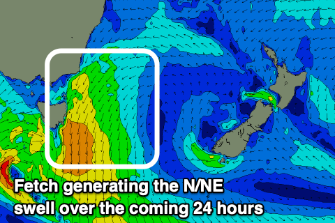 Tomorrow morning looks to be the pick of the period with the trough that's currently moving in from the west, squeezing a strong high east of us, bringing strengthening and broadening N/NE winds through our north-eastern swell window.
This should be kicking up a bit of size this afternoon, with a peak due tomorrow morning to a fun 3ft+ across most open beaches along with a N/NW tending W/NW breeze ahead of a gusty S/SE change early afternoon.
Fun waves are expected all day, though smallest into the afternoon as the change moves through.
The trough linked to the change in winds will deepen off the southern NSW coast mid-late week but sit too far north of our swell window to generate any meaningful swell.
Instead it'll bring persistent S/SW tending SE winds with tiny levels of swell into the end of the week.
As we move into the weekend though we'll see the low drifting south-east and broadening in scope, opening us to a broader fetch of strong SE winds. This should bring some E/SE windswell on the weekend but with onshore SE tending E and then NE winds.
There'll be nowhere to hide from the wind and size wise it looks to peak around 3ft+ Sunday afternoon and Monday.
Longer term there's nothing too major on the cards, but more on this Wednesday.