Good SE groundswell followed by NE

Eastern Tasmania Surf Forecast by Craig Brokensha (issued Monday 28th June)
Best Days: South magnets tomorrow, Wednesday and Thursday, Sunday through early next week
Features of the Forecast (tl;dr)
Recap
- Easing S swell tomorrow with NW tending N winds
- Good, inconsistent SE groundswell for Wed under NW tending N/NW winds, easing Thu with fresh N/NW winds
- NE swell potential from Sun onwards
This weekend and next week (Jun 29 – Jul 4)
Today's S'ly swell is expected to ease late today, dropping back further through tomorrow from 2-3ft on the south swell magnets. A NW tending N breeze will favour these locations but get in early for the most size.
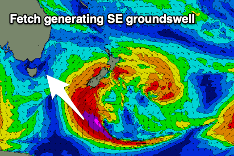 Into Wednesday, our SE groundswell is on track, generated by the backside of the polar low linked today's S'ly swell.
A great fetch of severe-gale to storm-force S/SE tending S winds have and are still being generated in our swell window, south of New Zealand.
By this evening the low will be out of our swell window, with the groundswell due to spread up and into us, arriving just before dawn Wednesday.
Open beaches should see good 3-4ft surf towards northern ends as it peaks through the day and under a NW tending N/NW breeze.
Thursday morning looks to still be around 3ft+ or so, but less consistent, easing back through the day under fresh N/NW breezes.
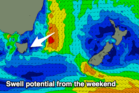 As we head into the weekend there are a couple of potential swell sources to keep an eye on.
A mid-latitude low forming west of us, and slowly moves east, looks to squeeze a strong high pressure system sitting over New Zealand. This will aim a strengthening fetch of N/NE winds through our swell window, with building levels of NE swell due off this source from Sunday.
To what size is unsure but we're looking at maybe sets to 3ft+ or so. More on this in the coming updates though.