Nothing major until early next week

Eastern Tasmania Surf Forecast by Craig Brokensha (issued Wednesday 23rd June)
Best Days: Monday and Tuesday south swell magnets
Features of the Forecast (tl;dr)
Recap
- Tiny N/NE windswell tomorrow and Fri
- Flukey S groundswell for Fri PM and Sat AM
- Better S'ly groundswell for Mon with W tending NE winds, easing Tue with strengthening N winds
This weekend and next week (Jun 24 - 27)
A fetch of N tending N/NW winds off the southern NSW coast today and tomorrow doesn't look to generate much in the way of surf.
A dribble of swell to 1-1.5ft may be seen across the north swell magnets but N/NW winds will create poor conditions at these spots tomorrow, cleaner Friday with a W tending variable breeze.
 On Friday and Saturday morning we may see a fleeting, tricky pulse of S'ly groundswell from W'ly gales pushing along the polar shelf. Confidence regarding any size of this source is low and south magnets may see 2ft sets.
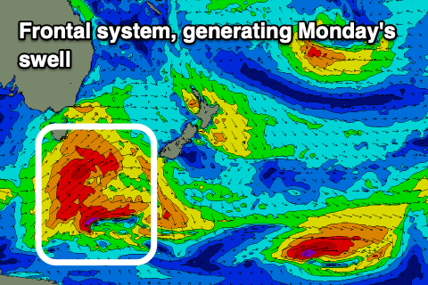
A much better swell producer is due to fire up through our swell window on Saturday evening and Sunday though, with a strong polar front due to project gale-force SW winds under the state and south-southeast of us.
This should produce a better, moderate sized S'ly groundswell for Monday, coming in at 4-5ft across the south swell magnets, holding most of the day.
This looks to be with light W tending NE winds, strengthening from the N'th on Tuesday as the swell eases from 3ft+.
It's worth making the most of as beyond this the outlook remains slow for the rest of the week. There's an outside chance for a small SE groundswell mid-week from a small intensification of gales under New Zealand, but we'll have a closer look at this Friday.