North and then south

Eastern Tasmania Surf Forecast by Craig Brokensha (issued Monday 24th May)
Best Days: Northern corners late tomorrow, Wednesday morning, Friday and Saturday protected spots, Sunday, Monday morning
Features of the Forecast (tl;dr)
- Building N/NE windswell tomorrow with fresh N/NW tending stong N winds, easing Wed with strong N/NW tending W/NW and then W/SW winds
- Small E swell for Thu
- Building S swell Fri with strong S/SW tending S winds, easing out of the S/sE Sat with fresh S/SW tending S winds
- Good SE groundswell for Sun with W/SW tending N/NE winds
Recap
Tiny to flat surf on the weekend but we should be seeing some N/NE windswell building across the coast late today.
This week and weekend (May 25 - 30)
After a bit of a downgrade on the expected N/NE swell due tomorrow and Wednesday on Friday, we've now got a more robust and healthier fetch of N/NE winds due to develop in our swell window over the coming day or two, producing a better, more powerful swell.
We'll see a strong mid-latitude low pushing in from the west, squeezing a strong high in the Tasman Sea, producing broadening and strengthening N winds that will reach just below gale-force strength.
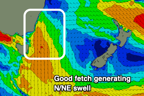 Building surf from 2-3ft tomorrow morning, up to 3ft+ late afternoon but with N/NW tending strong N winds.
The swell should peak Wednesday morning to 3ft+ but with a bit more power and strength, then easing rapidly through the day under strong N/NW tending W/NW winds, W/SW late afternoon.
Thursday may see a small E'ly swell to 1-2ft from strong E/SE winds off New Zealand's North Island but we've got a more significant swell event on the way.
As touched on last update, the backside of the low is set to produce some decent swell from the southern and south-eastern quadrant as it pushes into the Tasman Sea and deepens.
On Friday we're set to see a good fetch of strong to gale-force S'ly winds projecting up, past us, kicking up a moderate-large sized mix of mid-period and S'ly groundswell.
South facing beaches should reach 6ft, much smaller at other locations and with less than favourable strong S/SW tending S winds.
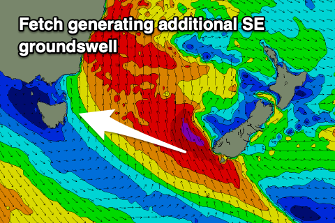 The swell will ease rapidly into Saturday but tend S/SE in direction and a secondary push of S/SE gales off New Zealand's South Island should generate a good, reinforcing SE groundswell for Sunday afternoon.
Size wise south facing beaches should ease from 4-5ft Saturday, with the new groundswell spiking back to 4-5ft+ on Sunday.
Winds will improve, but still be fresh and S/SW tending S on Saturday, much better Sunday and W/SW through the morning ahead of N/NE sea breezes.
Longer term there's nothing too significant compared to what's currently on the table, but more on this Wednesday.