Varying pulses of south swell

Eastern Tasmania Surf Forecast by Craig Brokensha (issued Wednesday 7th April)
Best Days: Open beaches for the keen Saturday, late Sunday, Monday morning, Tuesday morning south facing beaches
Features of the Forecast (tl;dr)
- Fleeting pulse of weak S swell Fri PM, gone Sat
- Small, NE swell for Sat with fresh W/NW-NW winds
- New S swell building late Sun with W/SW tending SW winds, holding Mon AM with W/SW tending S winds, fading Tue with morning NW winds
Recap
A continuation of tiny surf across the coast the last two days.
This week and next (Apr 8 - 16)
Tomorrow looks tiny, but looking at the hybrid low that's currently off the northern NSW coast, generating pumping surf in selected spots, it looks less and less like a swell producer with it now due to remain relatively weak and on the edge of our swell window through its lifetime.
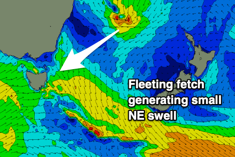 When it tracks south-east more into our swell window tomorrow, it'll be too quick, hence putting a cap on any major size. We're now looking at an inconsistent 2ft wave out of the NE on Saturday, fading Sunday.
Looking at the cold front pushing up past us Friday and it'll be so short-lived and not overly strong, that any size seen into the afternoon (maybe 2ft on the south magnets) will be gone Saturday.
Winds Friday afternoon will be out of the S/SW, creating bumpy conditions, W/NW-NW on Saturday, favouring open beaches with the small NE swell.
Moving into Sunday and the stronger cold outbreak across the state, this change in wind and weather is a result of a weakening 'bombing' low moving up and across us, but all of its swell generating will be done to our west.
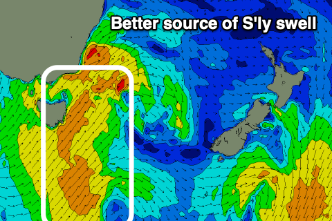 As it moves up past us Sunday a weaker fetch of S/SW winds will be projected through our swell window, generating a pulse of mid-period S'ly swell that'll build into the afternoon, reaching 4ft+ or so, better Monday with easing sets from 4ft and a greater spread into the coast.
Winds on Sunday look workable, fresh W/SW tending SW, with Monday seeing W/SW tending S winds through the day. Winds should revert back to the NW Tuesday favouring the south swell magnets as the swell fades from 2ft.
Longer term it looks like we'll see small pulses of S'ly swell late next week and into the weekend, but more on this Friday.
Comments
Just wondering if east facing beaches like eaglehawk neck down south are likely get any of this swell next weekend or is it too south west direction?
Yeah, looks too west if you're talking about the large stuff due into the South Arm.
Thanks Craig, was just reading the above east coast forecast and wondering if that applies also for eagle hawk neck or mainly for the south facing beaches on easy coast?
Yeah mainly north of EHN. From Friendly's to Eddystone.
Thanks!