Surf the existing swell then watch late next week

Eastern Tasmania Surf Forecast by Craig Brokensha (issued Friday 12th February)
Best Days: This afternoon, tomorrow morning, late next week and next weekend
Features of the Forecast (tl;dr)
- Easing mix of N/NE and E/SE swell tomorrow with W/SW tending SE winds
- Small, weak E swell for Wed but with N/NW tending NE winds, a touch stronger Thu with E/NE winds
- Stronger E/NE groundswell building Fri PM with N/NE winds, easing Sat as N/NE winds persist, smaller Sun with a S change
Recap
Nothing of note yesterday until late in the day with a building N/NE windswell, peaking today in the 3ft+ range with improving winds, easing and swinging more offshore. There's also an E/SE groundswell in the mix providing fun options across northern ends of beaches.
This week and weekend (Feb 2 - 7)
We'll see today's mix of E/SE groundswell and N/NE windswell dropping back quite a bit in size overnight so make the most of today. Easing 2ft sets are likely, tiny into the afternoon with a W/SW tending SE breeze.
There's a small period pulse showing on the charts out of the E/NE on Sunday but there'll be no size linked to this with tiny surf due through until at least Tuesday and more so Wednesday.
Looking at next week's developments and dynamic is the key word!
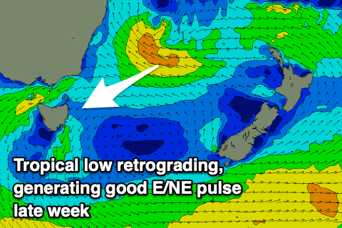
The surface trough slipping up past us tomorrow, bringing the SE change will linger in the Tasman Sea but then strengthen and team up with a tropical depression shifting south from Fiji.
This will happen as a high moves in under the southern Tasman Sea, supporting these deepening features, setting up a broad initial fetch of strong SE winds. This will be at right angles to our swell window, with small levels of E'ly swell spreading out radially towards us.
The low across the north of New Zealand is then expected to retro-grade, projecting a much better fetch of of E/SE winds through our north-eastern swell window mid-late week, generating a better, moderate-large size pulse of E/NE groundswell.
 So looking at the swell evolution and a late increase in new E'ly swell is likely Tuesday but with NE winds, coming in at 2ft+ Wednesday though winds look to be onshore out of the E/NE.
A touch more energy is likely Thursday but only to 2-3ft, mixed in with some localised NE windswell, with Friday seeing the groundswell arriving into the afternoon, kicking to 4-5ft+, easing slowly from 4-5ft Saturday morning.
Local winds at this stage look less than ideal and out of the N/NE on Friday and Saturday ahead of a trough and change Sunday, but we'll have a closer look at this Monday. Have a great weekend!