Make the most of the easing swell

Eastern Tasmania Surf Forecast by Craig Brokensha (issued Wednesday 30th September)
Best Days: Tomorrow, early Friday
Recap
Fun waves yesterday with an easing S'ly groundswell and clean conditions, while today a new, strong SE groundswell should have filled in across the coast and reached 5-6ft on the sets.
This week and weekend (Oct 1 - 4)
Today's strong SE groundswell is due to peak overnight and we'll see it easing back tomorrow, likely from 3-5ft on the swell magnets, smaller and from 2ft on Friday.
Winds look favourable for these magnets and offshore from the W/NW tomorrow morning, holding across the northern part of the state into the afternoon and becoming more variable NE to the south.
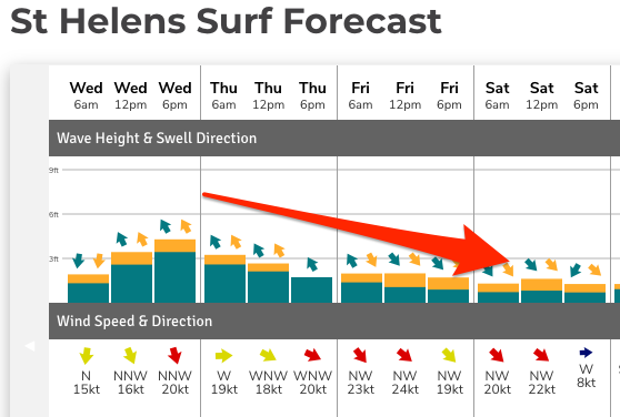 Strong NW winds should then be seen most of Friday.
There'll also likely be a small hint of N/NE windswell in the mix tomorrow, but below the SE groundswell.
Following this there's nothing significant for the weekend as mid-latitude fronts push east-southeast across the state, with a possible small N/NE windswell developing on dark Sunday, fading from 1-2ft Monday.
A S'ly change through Monday doesn't look to bring much in the way of S'ly swell behind it, with our attention shifting to a deepening inland trough drifting in from the east next week.
This may deepen into a low, with a great infeed of NE gales and building, stormy N/NE swell mid-late next week, but we'll have to go over this again on Friday. The models are fairly divergent on what could occur into next week.