Hold tight until next Tuesday

Eastern Tasmania Surf Forecast by Craig Brokensha (issued Friday 24th July)
Best Days: Tuesday, Wednesday, Thursday, Friday keen surfers
Recap
Small to tiny levels of background S'ly swell and basically unsurfable except for a longboard.
This weekend and next week (Jul 25 – 31)
The weekend and Monday will remain void of swell but moving into Tuesday and Wednesday, we should see our good pulse of NE tending E/NE groundswell from a deepening low in the Tasman Sea.
Currently a deepening surface trough sitting off the south-east QLD and northern NSW coasts is bringing rain and strengthening E/NE winds feeding into its eastern flank.
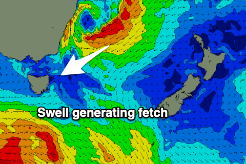 Through the weekend we'll see the trough slowly drifting south and deepening before forming a low pressure centre Sunday afternoon.
As it drifts south and deepens, a strengthening and broadening fetch of strong NE winds will move into our swell window, reaching gale-force overnight Sunday and more so Monday morning.
The low is then forecast to track quickly to the south-east through Monday evening and Tuesday, cutting off the infeed of E/NE winds, while a fetch of strong SE winds will develop just within our swell window on its south-western flank.
What we can expect is a rapid increase in NE groundswell through Tuesday owing to the projection of the fetch towards us, likely peaking later in the day, coming in a similar size Wednesday morning out of the E/NE and then easing rapidly Thursday.
Size wise swell magnets open to the north-east energy should build from 3ft early to 4-6ft later in the day, then easing from a similar size Wednesday morning.
Thursday looks much smaller and dropping quickly from the 4ft range.
Local winds look to improve through Tuesday as a cold front moves in, swinging from S/SW to SE and them NE, much better Wednesday and fresh out of the NW. Thursday looks great as well with W'ly tending variable winds.
Longer term there's plenty more activity on the cards with another deepening trough likely to generate some smaller and less consistent NE energy through next weekend. More on this Monday. Have a great weekend!