New south swell tomorrow

Eastern Tasmania Surf Forecast by Craig Brokensha (issued Monday 6th April)
Best Days: Tomorrow, Wednesday morning protected spots, Thursday south swell magnets
Recap
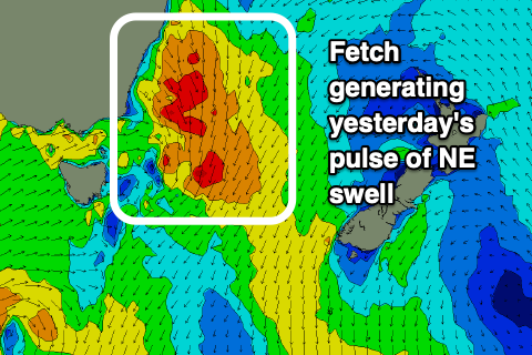
Still 3ft of swell reported on the coast Saturday morning which is puzzling as the swell source long left the building on Friday morning. Sunday started tiny but again the swell kicked to 3-4ft, the only source being this fetch of winds that were angled a little more favourably for swell generation than expected on Friday.
This swell was gone by this morning with a tiny leftover 1-1.5ft wave on the coast
This week and weekend (Apr 7 - 12)
With the weekend not playing quite out to plan we've got a more reliable S'ly swell due over the coming days.
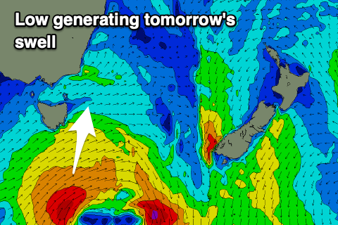 A tight low come polar front has been projecting a fetch of strong to gale-force S/SW winds through our southern swell window yesterday and today, with a moderate sized S'ly groundswell due tomorrow, peaking into the afternoon. From here the swell will slowly drop away, slowed a little into Thursday as weak trailing polar front moves through our swell window.
A solid kick to 5-6ft is expected across the south swell magnets, with a morning W/SW offshore, giving into afternoon sea breezes.
Wednesday looks less favourable as a weak front pushes up past us bringing fresh S/SW tending S/SE winds and easing sets from 4ft or so on the south magnets.
Thursday will be nice and clean on the south facing beaches as the swell drops further from 2ft+ with a W/NW tending N/NE breeze.
Looking into the weekend and the models diverge on the progression of a series of polar fronts across and south of us into this weekend. Depending on their track and strength we'll see changes in the expected S'ly swell but at this stage none of it looks as big as tomorrow's so make the most of it.