Average few days, much more interesting next week

Eastern Tasmania Surf Forecast by Craig Brokensha (issued Wednesday 11th March)
Best Days: Friday keen surfers, next week
Recap
Monday's good spike in E/SE swell dropped back in size to 3ft+ across the coast yesterday, with this morning smaller and back to 2ft on the sets.
This week and weekend (Mar 12 - 15)
Tomorrow looks to be a lay day while a weak fetch of N/NE winds developing off the coast during Thursday afternoon and evening should generate 2ft of N/NE windswell into Friday (possibly rare bigger lump) along with N/NW winds, shifting W/NW mid-afternoon ahead of a late S'ly change.
This change has been upgraded in strength and we'll see a fetch of strong S'ly winds projecting up past us Friday evening, producing a kick in S'ly swell to 3ft+ Saturday morning but with gusty S/SW tending S/SE-SE winds (not ideal).
 Sunday morning should be a little cleaner but the S/SE windswell will be easing from a weak 1-2ft.
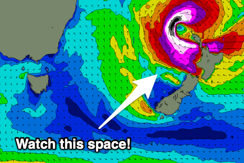
The front linked to Friday's change is due to spawn into a weak low north-east of us on the weekend, producing some small E'ly swell for early next week, while a tropical cyclone forming off the QLD coast looks to move quickly south-east and be absorbed into the Tasman Sea and deepen significantly off New Zealand's North Island.
What this is set to generate is a strong E/NE groundswell later next week for our region. With the fun E'ly mid-period swell early week. So we've got a more than active period of surf ahead. Check back Friday for more details.