Large E/SE groundswell inbound

Eastern Tasmania Surf Forecast by Craig Brokensha (issued Monday 17th February)
Best Days: Tomorrow, Wednesday, Thursday, Friday morning, Saturday morning
Recap
The large NE groundswell from Tropical Cyclone Uesi filled in strongly Saturday, a little undersized in the morning but kicking to 6-8ft across north-east swell magnets into the afternoon with favourable winds for protected southern corners.
The swell started to ease into Sunday from the 6ft range with southerly winds, smaller again today with 3-4ft sets left in the mix.
This week and weekend (Feb 18 - 21)
So far so good, the swell from Uesi has peaked later Saturday, easing since and we'll see a low point overnight ahead of some new building SE swell tomorrow and larger E/SE groundswell into the afternoon and Wednesday morning.
This new swell energy will be from the remnants of Uesi moving down towards New Zealand's South Island, generating a broad fetch of strong SE winds which reached gale-force last night and early this morning, producing the largest pulse of size.
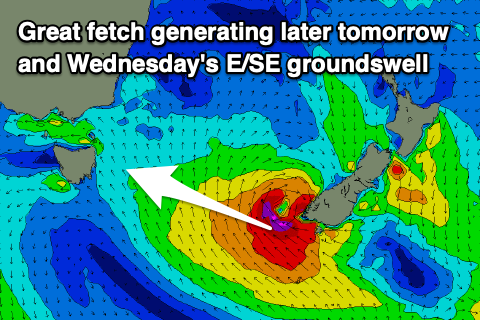 So tomorrow morning we should see some new mid-period SE swell to 3-5ft or so in the morning, kicking to 4-6ft through the afternoon with the groundswell energy, holding Wednesday morning to 5-6ft.
Also in the mix Wednesday will be a localised S/SE windswell as a strong low drifts down and off the coast, bringing strong S/SW tending S winds. Looking at tomorrow though, a light W'ly offshore is due to give into afternoon sea breezes, swinging S'ly late, so try southern corners.
As the swells ease on Thursday a morning SW breeze is expected, shifting S/SE into the afternoon and then more E. The E/SE groundswell should be on the ease, dropping back from 4-5ft, mixed in with mid-period SE swell.
Friday looks to be a low point ahead of a late increase in S'ly swell, but more so Saturday.
This will be generated by a deepening low forming south-west of the state and projecting a fetch of strong to gale-force SW winds north-east through our southern swell window.
While there may be signs of the swell late Friday, Saturday morning should reveal the peak with sets to 3-4ft out of the south with SW tending E winds.
We'll have a closer look at this on Wednesday and Friday though.
Following this the outlook is quieter, so make the most of the coming waves!