Small N/NE followed by S

Eastern Tasmania Surf Forecast by Craig Brokensha (issued Friday 3rd January)
Best Days: Later tomorrow north-east swell magnets, later Sunday south swell magnets, early Monday south swell magnets
Recap
Our flukey and inconsistent groundswell from TC Sarai was just that, offering only small waves on the coast for desperate surfers.
This weekend and next week (Jan 4 - 10)
Any groundswell will be replaced by N/NE windswell tomorrow, generated by an elongated but weak fetch of N/NE winds developing off our coast tomorrow this evening and tomorrow.
The size looks to peak into the afternoon to 2ft+ or so, with possibly 3ft sets at true swell magnets as winds swing from the N/NW in the morning to S-S/SW later afternoon/evening.
This change will be linked to a 'bombing low' moving quickly east under the state.
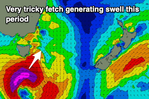 A 'bombing low' is a storm that drops 24hPa or more in central pressure in a period of 24 hours, and this will happen through Saturday.
The low is expected to generate a fast moving fetch of severe-gale to storm-force W/SW winds while tracking south-east.
This isn't ideal for swell production and our models aren't picking up any considerable increase in size, but we should see the swell spike out of the south Sunday to 3ft to likely 5ft across south swell magnets, fading rapidly into Monday.
Winds will be average for these locations Sunday morning and S/SW, shifting NE into the late afternoon and evening, creating improving conditions for northern corners. Monday morning looks clean as the swell fades.
Longer term there's nothing too significant for our region besides small to tiny and weak levels of E/NE-N/NE swell. More on this Monday. Have a great weekend!