Southerly and then north-east swells

Eastern Tasmania Surf Forecast by Craig Brokensha (issued Monday 16th September)
Best Days: South magnets tomorrow morning, Thursday south magnets, Friday northern corners, Saturday, Sunday morning
Recap
Tiny surf on the weekend, similar today, though a front pushing up past us this afternoon should have kicked up a small increase in windswell.
Today’s Forecaster Notes are brought to you by Rip Curl
This week and weekend (Sep 17 - 22)
The front moving up past us this afternoon should produce a small spike in S'ly swell to 3ft on the sets across south magnets tomorrow morning, easing through the day.
 Winds will be favourable and W/NW through the morning gusty N'ly into the afternoon as the swell eases.
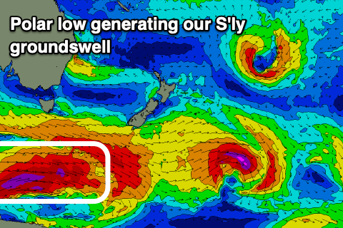
Into Thursday a real acute but strong S'ly groundswell should be seen across select south swell magnets, generated by a strong polar low moving through our southern swell window tomorrow and Wednesday. A fetch of polar storm-force W/SW winds will generate the swell, with it peaking through the morning across south facing beaches to 3-5ft, much more than the models are forecasting.
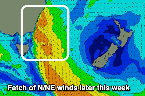
There'll also be a building N/NE windswell in the mix from a strengthen fetch of N/NE winds down the coast, building to 3ft later along with strong N/NW tending N/NE winds.
The S'ly swell will fade into Friday but the N/NE fetch will broaden and strengthen through the day, producing a further increase in N/NE swell through the day to the 4ft range along with N tending N/NE winds.
 A weakening front moving in from the west on Friday evening will bring a NW change on Saturday along with the easing N/NE swell from 4-5ft as winds strengthen overnight just ahead of the change.
Sunday will be cleaner again but the swell fading rapidly from 2ft+.
Longer term there's nothing too significant on the cards so make the most of the coming week of waves.