Fading S swell with a good E/NE swell lining up for next week

Eastern Tasmania Surf Forecast by Craig Brokensha (issued Monday 24th June)
Best Days: South swell magnets tomorrow morning, next week
Recap
Our secondary pulse of SE swell came in around the expected 3-5ft on Saturday with better winds than forecast, while Sunday was clean again with easing 3ft sets.
A new S'ly groundswell should have started to show today, peaking this afternoon to 4ft across south swell magnets.
Today’s Forecaster Notes are brought to you by Rip Curl
This week and weekend (Jun 25 - 30)
Today's S'ly groundswell will drop back rapidly through tomorrow, so get in early for the most size. South magnets should hopefully see sets to 2-3ft, tiny into the afternoon and with a persistent NW offshore wind.
Following this there's nothing significant on the cards until late week and more so the weekend.
 A strong blocking high will move slowly east as cold fronts moving in from the west progress further towards us.
This will squeeze the western flank of the high and direct a N'ly fetch through our northern swell window, not reaching any significant strength until Saturday.
The alignment isn't great but with 18 hours of strong N'ly winds we should see a kick in N/NE windswell on the coast Saturday afternoon to 2ft to maybe 3ft at north-east facing beaches though with poor N tending N/NW winds.
A W/SW change will be seen overnight but come Sunday morning the swell looks to be fading from a small 2ft max across north-east magnets.
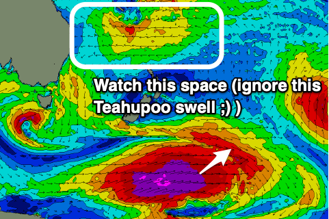
Of greater importance are the developments on the northern flank of the high, with a deepening tropical low expected to form in an established trade-flow, directing a fetch of strong to gale-force E/NE winds through our swell window north of New Zealand this week.
We may even see the fetch swing more NE and encroach into the Tasman Sea as a low pushes off the Australian mainland and stalls in the Tasman Sea, though we'll have to review this in the next few updates.
A prolonged E/NE groundswell event is a possibility, building early next week and peaking Wednesday/Thursday to what at this stage looks to be 4-5ft+ or so. Check back here through the week for updates.