Really fun outlook for next week

Eastern Tasmania Surf Forecast by Craig Brokensha (issued Friday 3rd May)
Best Days: Next week from Tuesday
Recap
A drop in N/NE windswell from Wednesday into yesterday, while today was much cleaner with small easing surf from 2ft+ across the north-east magnets.
Today’s Forecaster Notes are brought to you by Rip Curl
This weekend and next week (May 4 - 10)
There isn't expected to be any size left to the NE swell tomorrow with tiny waves on the coast, while a weak S'ly change moving up through the day doesn't look to produce any meaningful size for Sunday.
South facing beaches up the northern end of the coast may see 2ft to possibly 3ft sets early, easing through the day and with poor S/SW tending S/SE winds.
 Now the dynamics around the strong Tasman Low that was forecast by most of the models to form east of us has changed.
We're still due to see the low form, but further away and weaker.
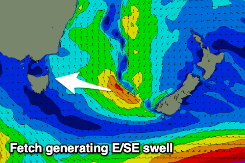
On Sunday we'll see the low form but closer to New Zealand's South Island, with a fetch of strong to possibly gale-force SE winds being produced in our eastern swell window, pushing back a little closer towards us on Monday while weakening.
This should produce a moderate sized E/SE swell, possibly showing later Monday but more so Tuesday with open beaches expected to pulse to 4-5ft. Winds look to improve as the low continues west, producing W'ly offshores, giving into weak afternoon sea breezes.
The E/SE swell is due to ease rapidly on Wednesday from 3-4ft or so, but an infeed of E/NE winds on the eastern side of the low should produce some good new E/NE swell for the afternoon and Thursday.
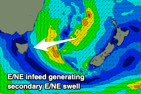 We're expected to see 3-4ft sets later Wednesday and Thursday morning from this source, easing slowly thereafter and with W/SW winds on the former, and NW tending W/SW winds Thursday.
Also in the mix of Monday should be a small S'ly groundswell from a polar fetch of W/SW gales tomorrow, providing 2-3ft sets into the afternoon, fading Tuesday. Wednesday will also see a S/SE groundswell from a good fetch of severe-gale to storm-force SE winds south of New Zealand, but this will be under the local SE and E/NE swells.
So all in all it's an active period from Tuesday, but check back here Monday for an update on the outlook. Have a great weekend!