Fun surf over the coming period

Eastern Tasmania Surf Forecast by Craig Brokensha (issued Wednesday 17th April)
Best Days: Tomorrow morning, Saturday south magnets, Sunday northern corners, Monday open beaches
Recap
A fun E/NE windswell to 2-3ft yesterday morning and that should have been replaced by a building N/NE windswell today along with strengthening N/NE winds.
Today’s Forecaster Notes are brought to you by Rip Curl
This week and weekend (Apr 18 - 21)
We've got a good period of waves on the cards, with strengthening N/NE winds currently down the coast producing a fun N/NE swell that will ease tomorrow as a W'ly change moves through.
 North-east magnets should see easing back from 2-3ft with a W/SW breeze, tending S/SW breeze.
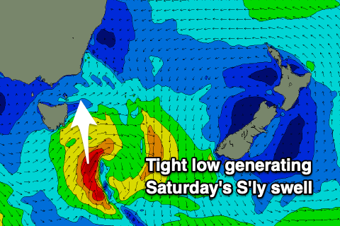
The front bringing this change will form into a small low south-southeast of us tomorrow, with a great fetch of S'ly gales just being generated in our southern swell window.
This should produce a fun S'ly swell that may be seen late Friday but will peak Saturday morning to 3ft across south magnets.
Winds should be favourable for these spots with a N'ly tending gusty N/NE breeze which will also kick up a new N/NE windswell, peaking Sunday to 2-3ft across north-east magnets.
Also in the mix should be a fun E/NE trade-swell from a stationary fetch of E'ly trades that is currently established north and north-west of New Zealand.
This trade-fetch will remain in our swell window until about Friday morning and then start retreating, with small and fun levels of E/NE trade-swell filtering down towards us from Friday, possibly building to 1-2ft by dark but building further Saturday afternoon to 3ft on the sets, easing from a similar size Sunday morning.
Winds on Sunday won't be great and from the N/NE most of the day, possibly tend N/NW later, with offshore W/SW winds on Monday, giving into NE sea breezes as the swells ease from 2ft.
Longer term there's nothing too significant on the cards so make the most of the coming days swell.